Date: Tue Jan 17 2012 - 14:17:52 MST
Hello!
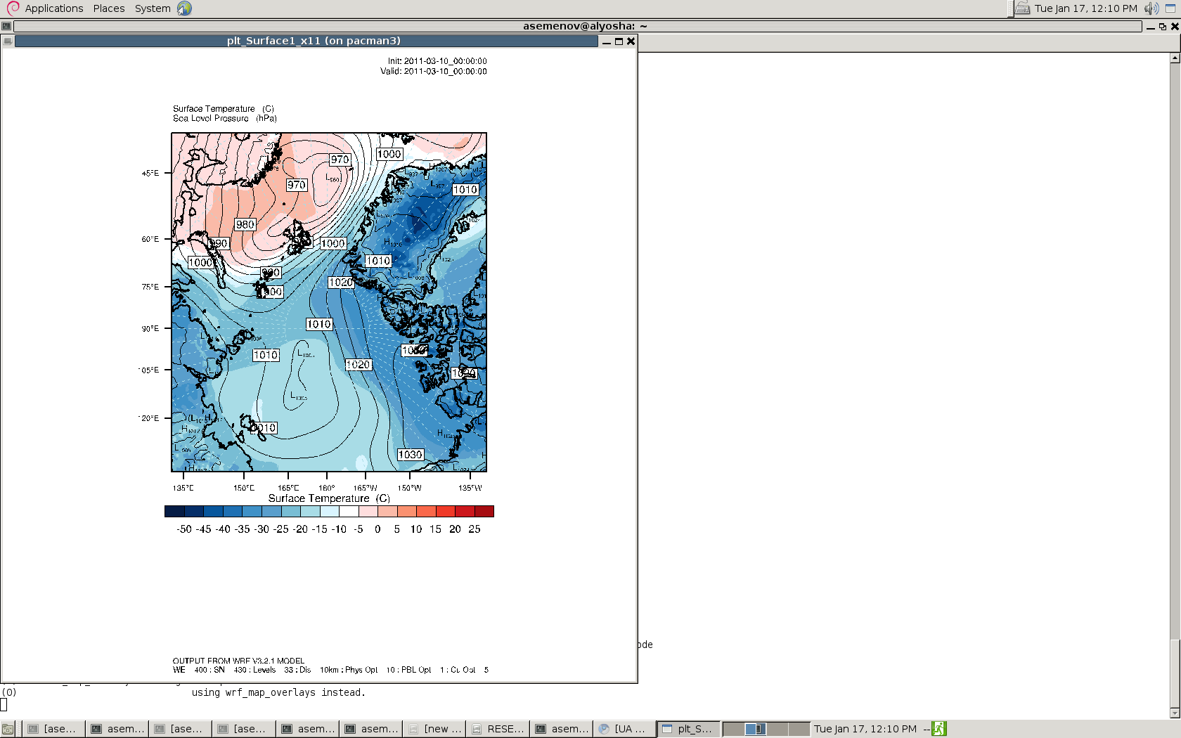
I have a problem with label height font! I want "L" and "H" (for low and
high pressure) have bigger font, more visible. I put "cnLowLabelFontHeightF
= 0.04" operator but nothing changes. I tried putting 0.4 and different
values, the font size stays the same as before. Do you mind telling me
what's going on?
Second question is that the label bar stays the same place as before even
if specified that I want it vertical. What's wrong?
Third question is on the size of the font of everyhting outside of the map.
It doesn't change?!
Third
I run ncl/6.0.0
; Example script to produce plots for a WRF real-data run,
; with the ARW coordinate dynamics option.
load "$NCARG_ROOT/lib/ncarg/nclscripts/csm/gsn_code.ncl"
load "$NCARG_ROOT/lib/ncarg/nclscripts/wrf/WRFUserARW.ncl"
;load "WRFUserARW.ncl"
begin
a =
addfile("/import/wrkdir1/asemenov/WRF/WRFV3/10_25.03_res_30_10km/wrfout_d02_2011-03-10_00:00:00"+".nc",
"r")
type = "x11"
wks = gsn_open_wks(type,"plt_Surface1")
gsn_define_colormap(wks,"temp_diff_18lev")
ARWres = True
times = wrf_user_list_times(a) ; get times in the file
ntimes = dimsizes(times) ; number of times in the file
;;;;;;;;;;;;;;;;;;;;;;;;;;;;;;;;;;;;;;;;;;;;;;;;;;;;;;;;;;;;;;;;
do it = 0,ntimes-1,2 ; TIME LOOP
print("Working on time: " + times(it) )
ARWres@TimeLabel = times(it) ; Set Valid time to use on plots
mpres = True ; Create map background
mpres@mpProjection = "Stereographic"
mpres@mpLimitMode = "Corners"
mpres@mpMinLatF = 60
mpres@mpCenterLatF = 90
mpres@mpCenterLonF = -180
mpres@mpGridLineDashPattern = 2
mpres@mpGeophysicalLineColor = "Black"
mpres@mpGeophysicalLineThicknessF = 1.5
mpres@mpNationalLineColor = "Black"
mpres@mpNationalLineThicknessF = 1.5
mpres@mpUSStateLineColor = "Black"
mpres@mpUSStateLineThicknessF = 1.5
mpres@mpPerimLineColor = "Black"
mpres@mpDataBaseVersion = "MediumRes"
mpres@mpFillOn = False
mpres@gsnStringFontHeightF = 0.045
mpres@cnInfoLabelOn = False
mpres@lbOrientation = "vertical"
map = wrf_map(wks,a,mpres)
;;;;;;;;;;;;;;;;;;;;;;;;;;;;;;;;;;;;;;;;;;;;;;;;;;;;;;;;;;;;;;;;
; First get the variables we will need
slp = wrf_user_getvar(a,"slp",it) ; slp
wrf_smooth_2d( slp, 3 ) ; smooth slp
if ( it .eq. 0 ) then
tc = wrf_user_getvar(a,"tc",it) ; 3D tc
u = wrf_user_getvar(a,"ua",it) ; 3D U at mass points
v = wrf_user_getvar(a,"va",it) ; 3D V at mass points
tc2 = tc(0,:,:) ; Use lowest T at time zero
else
tc2 = wrf_user_getvar(a,"T2",it) ; T2 in Kelvin
tc2 = tc2-273.16 ; T2 in C
end if
tc2@description = "Surface Temperature"
tc2@units = "C"
;;;;;;;;;;;;;;;;;;;;;;;;;;;;;;;;;;;;;;;;;;;;;;;;;;;;;;;;;;;;;;;;
; Plotting options for T
opts = ARWres
opts@cnFillOn = True
opts@ContourParameters = (/ -50., 25., 5./)
opts@gsnSpreadColorEnd = -3 ; End third from the last color in color
map
contour_tc = wrf_contour(a,wks,tc2,opts)
delete(opts)
; Plotting options for SLP
opts = ARWres
opts@cnLineColor = "Black"
opts@cnHighLabelsOn = True
opts@cnLowLabelsOn = True
opts@cnLowLabelFontHeightF = 0.04
opts@ContourParameters = (/ 940., 1044., 4. /)
opts@cnLineLabelsOn = True
opts@cnLineLabelPerimOn = True
opts@cnLineLabelBackgroundColor = 0.
opts@cnLineLabelFontHeightF = 0.015
opts@cnInfoLabelOn = False ; turn off info label
opts@cnLevelSpacingF = 0.1 ; set contour spacing
opts@gsnCenterString = "Default Line Label Settings"
opts@cnLineLabelDensityF = 1.5 ; increase the number
of line labels/line
opts@cnLineLabelInterval = 2 ; labels for every line
(default=2)
opts@cnLabelMasking = True ; do not draw labels
over contour
opts@gsnCenterString = "Label Masking"
opts@gsnContourLineThicknessesScale = 1.0
contour_psl = wrf_contour(a,wks,slp,opts)
delete(opts)
; MAKE PLOTS
wrf_map_overlay(wks,map,(/contour_tc,contour_psl/),True)
;;;;;;;;;;;;;;;;;;;;;;;;;;;;;;;;;;;;;;;;;;;;;;;;;;;;;;;;;;;;;;;;
end do ; END OF TIME LOOP
end
--
regards
*******************************************************
*Alexander Semenov*
PhD Student - Research Assistant
International Arctic Research Center
Department of atmospheric sciences
University of Alaska Fairbanks
_______________________________________________
ncl-talk mailing list
List instructions, subscriber options, unsubscribe:
http://mailman.ucar.edu/mailman/listinfo/ncl-talk