Date: Sun Sep 15 2013 - 17:20:04 MDT
Hi there,
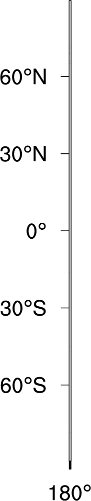
I found I could not get the correct global lat-lon plot using the gWRF_merc.ncl (or other script, like wrf_Cloud.ncl at http://www.mmm.ucar.edu/wrf/OnLineTutorial/Graphics/NCL/NCL_examples.htm). The same problem has been found before (however, without solving it), dated back to 2009 (http://www.ncl.ucar.edu/Support/talk_archives/2009/1743.html), which shows only a thin vertical bar at 180 degree (longitude) instead of the global view.
I've tested using the simple script that Mary Haley suggested (http://www.ncl.ucar.edu/Support/talk_archives/2009/1751.html). The 1st frame shows the exact problem described above (see attached figure). The 2nd frame is fine, while the 3rd frame is very large and only part of the map is shown.
I've also tested the same code on regional simulation, which shows no problem. That's very strange. Could you please help on this?
P.S I used ncl version 6.1.2 and WRF v3.5 for a global simulation.
Thanks,
Best,
Eddy
_______________________________________________
ncl-talk mailing list
List instructions, subscriber options, unsubscribe:
http://mailman.ucar.edu/mailman/listinfo/ncl-talk