Date: Mon Sep 16 2013 - 14:24:14 MDT
Hello everybody,
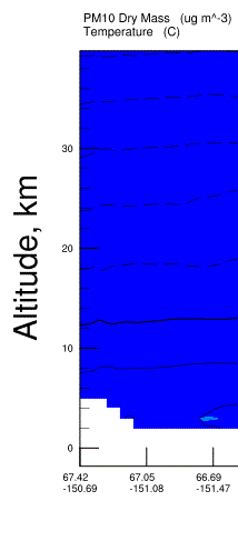
I have a simple problem with my Y-axis label. In my code, I locate the
problem by commenting "MY PROBLEM IS HERE" just for ease. I have also
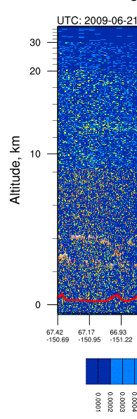
attached pictures of what my current plot is (WRF Y-Axis.gif) and what I
want the y-axis to be (Ideal Y-Axis.gif).
I have an irregular y-axis issue. My file, "lidar_altitudes.txt", lists
irregularly-spaced height values that are representative of CALIPSO's range
gates. I would like for the y-axis on my WRF cross-section to be
representative of those height values.
However, I get the error message: "warning:trYCoordPoints is not a valid
resource in WRF Cross Section_contour at this time", and my plot remains
the same.
What am I missing? I have looked for additional resources, but none of
those offerings have helped.
Thank you much, my code is below.
Mike
Code:
; This script will take a cross section of your WRF data, with specified
; latitude and longitude coordinates.
load "$NCARG_ROOT/lib/ncarg/nclscripts/csm/gsn_code.ncl"
load "$NCARG_ROOT/lib/ncarg/nclscripts/wrf/WRFUserARW.ncl"
load "$NCARG_ROOT/lib/ncarg/nclscripts/csm/gsn_csm.ncl"
load "$NCARG_ROOT/lib/ncarg/nclscripts/csm/contributed.ncl"
load "$NCARG_ROOT/lib/ncarg/nclscripts/csm/shea_util.ncl"
load "$NCARG_ROOT/lib/ncarg/nclscripts/contrib/ut_string.ncl"
load "color_map.ncl"
begin
type = "x11"
wks = gsn_open_wks(type,"WRF Cross Section")
gsn_define_colormap(wks,"BlAqGrYeOrReVi200")
; Load CALIPSO latitude and longitude data
b =
addfile("/import/archive/u1/uaf/jmmadden/WILDFIRE2009/CALIPSOdata/SUBSETS/CAL_LID_L1-ValStage1-V3-01.2009-06-21T12-23-05ZD.hdf_Subset.hdf","r")
; Work with the time fields to get a valid time string
time = (/b->Profile_Time/)
time@units = "seconds since 1993-01-01 00:00"
tstring = ut_string(time(:,0), "%Y-%N-%D %H:%M:%S")
xlat = (/b->Latitude/)
xlon = (/b->Longitude/)
xlabel = sprintf("%.2f",xlat)+"~C~"+sprintf("%.2f",xlon)
asciiwrite("xlabel",xlabel)
n = dimsizes(xlat(:,0)) ; n is 1319 (1318 in some files, that's ok
nn = dimsizes(xlon(:,0)) ; n is 1319 (1318 in some files, that's ok
minlat = xlat(n-1,0)
maxlat = xlat(0,0) ; this is 67.xxx
minlon = xlon(nn-1,0)
maxlon = xlon(0,0) ; this is -150.xxx
lats = (/maxlat,minlat/)
lons = (/maxlon,minlon/)
;;;;;;;;;;;;;;;;;;;;;;;;;;;;;;;;;;;;;;;;;;;;;;;;;;;;;;;;;;;;;;;;
;;;;;;;;;;;;;;;;;;;;;;;;;;;;;;;;;;;;;;;;;;;;;;;;;;;;;;;;;;;;;;;;
; GET SPECIAL CALIPSO RANGE GATES (FOR Y-AXIS)
hgt = asciiread("lidar_altitudes.txt", -1, "float")
hgt = hgt(::-1) ; Reverse this array too
hgt!0 = "hgt"
hgt@long_name = "Altitude, km"
hgt@units = "km"
;;;;;;;;;;;;;;;;;;;;;;;;;;;;;;;;;;;;;;;;;;;;;;;;;;;;;;;;;;;;;;;;
; READ WRF OUTPUT FILE
a =
addfile("/import/archive/u1/uaf/jmmadden/WILDFIRE2009/WRFouts/wrfout_d01_2009-06-21_00:00:00"+".nc","r")
;;;;;;;;;;;;;;;;;;;;;;;;;;;;;;;;;;;;;;;;;;;;;;;;;;;;;;;;;;;;;;;;;
times = wrf_user_getvar(a,"times",-1) ; get times in the file
ntimes = dimsizes(times) ; number of times in the file
;;;;;;;;;;;;;;;;;;;;;;;;;;;;;;;;;;;;;;;;;;;;;;;;;;;;;;;;;;;;;;;;;
; Set some basic resources
res = True
res@MainTitle = "REAL-TIME WRF"
res@Footer = False
pltres = True
;;;;;;;;;;;;;;;;;;;;;;;;;;;;;;;;;;;;;;;;;;;;;;;;;;;;;;;;;;;;;;;;;;;
; HOURLY LOOP OF PARTICULATE MATTER
do it = 12,14 ; loop over 24 hours
print("Working on time: " + times(it) )
res@TimeLabel = times(it) ; Set Valid time to use on plots
; First get the variables we will need
tc = wrf_user_getvar(a,"tc",it) ; T in C
z = wrf_user_getvar(a, "z",it) ; grid point height
pm = a->PM10(it,:,:,:)
pm@description = "PM10 Dry Mass"
loc = wrf_user_latlon_to_ij(a,lats,lons)
ys = loc(0,0) ; Starting y (j) location
ye = loc(1,0) ; Ending y (j) location
xs = loc(0,1) ; Starting x (i) location
xe = loc(1,1) ; Ending x (i) location
; Interpolate WRF Model data vertically
angle = 0
opts = False ; start and end points not
specified
; Establish starting and end points in domain
plane = new(4,float)
plane = (/ xs,ys, xe,ye /) ; start x;y & end x;y point
pm_plane = wrf_user_intrp3d(pm,z,"v",plane,angle,opts)
xcoord = ispan(0,dimsizes(pm_plane(0,:)) - 1, 1) ; xcoord is 157
tc_plane = wrf_user_intrp3d(tc,z,"v",plane,angle,opts)
; Plotting Options for PM
opts_pm = res
opts_pm@cnLevelSelectionMode = "ExplicitLevels"
Levels = (/3.,3.5,4.,4.5,5.,5.5,6.,6.5,7.,8.,9.,11.,13.,15./)
opts_pm@cnFillOn = True
opts_pm@cnFillMode = "RasterFill"
opts_pm@cnRasterSmoothingOn = True
opts_pm@cnLinesOn = False ; turn off contour lines
opts_pm@cnLineLabelsOn = False ; turn off contour labels
opts_pm@tiYAxisOn = True
opts_pm@tiYAxisString = "Altitude, km"
opts_pm@tiXAxisString = "Latitude & Longitude"
opts_pm@tmXTOn = False
opts_pm@tmYROn = False
opts_pm@tmXBMode = "Explicit"
opts_pm@tmXBValues = xcoord(::15)
opts_pm@tmXBLabels = xlabel(::130,0)
opts_pm@tmXBLabelFontHeightF = 0.001
opts_pm@gsnMaximize = True
opts_pm@vpXF = 0.105
opts_pm@vpWidthF = 0.8551
opts_pm@vpYF = 0.84355
opts_pm@vpHeightF = 0.51
; MY PROBLEM IS HERE
opts_pm@trYAxisType = "IrregularAxis"
opts_pm@trYCoordPoints = hgt
opts_pm@trYMinF = min(hgt)
opts_pm@trYMaxF = max(hgt)
; PLOTTING OPTIONS FOR TEMPERATURE
opts_tc = res
opts_tc@ContourParameters = (/ 5. /)
opts_tc@gsnMaximize = True
opts_tc@vpXF = 0.105
opts_tc@vpWidthF = 0.8551
opts_tc@vpYF = 0.84355
opts_tc@vpHeightF = 0.51
opts_tc@trYMinF = min(hgt)
opts_tc@trYMaxF = max(hgt)
contour_pm = wrf_contour(a,wks,pm_plane,opts_pm)
contour_tc = wrf_contour(a,wks,tc_plane,opts_tc)
; RESOURCES FOR FINAL OVERLAY PLOT
pltres@gsnMaximize = True
pltres@vpXF = 0.105
pltres@vpWidthF = 0.8551
pltres@vpYF = 0.84355
pltres@vpHeightF = 0.51
plot = wrf_overlays(a,wks,(/contour_pm,contour_tc/),pltres)
end do
end
--
*Mike Madden
*
*Graduate Research Assistant *
*Department of Atmospheric Sciences *
*University of Alaska Fairbanks*
*IARC 338N
*
*Office:  (907) 474-7618
*
*Cell: (417) 439-2830
---------------------------------------------------------------------
"Buy the ticket, take the ride."  Hunter S. Thompson
*
_______________________________________________
ncl-talk mailing list
List instructions, subscriber options, unsubscribe:
http://mailman.ucar.edu/mailman/listinfo/ncl-talk