Date: Sun Jan 08 2012 - 04:38:58 MST
hi,
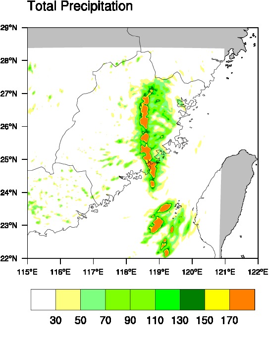
I use wrfout data to draw rainfall and i can get the picture. But its map has something wrong. ( attachment)
Can anyone give me some suggestions?
Thanks.
JinQ
--
JinQ,                          M.S.
Ocean University of China
--
scripts:
load "$NCARG_ROOT/lib/ncarg/nclscripts/csm/gsn_code.ncl"
load "$NCARG_ROOT/lib/ncarg/nclscripts/csm/gsn_csm.ncl"
load "$NCARG_ROOT/lib/ncarg/nclscripts/csm/contributed.ncl"
load "$NCARG_ROOT/lib/ncarg/nclscripts/wrf/WRFUserARW.ncl"
begin
  a = addfile("wrfout_d03_2010-09-09_12:00:00o.nc","r")
  type = "eps"
  wks = gsn_open_wks(type,"precip_all")
;;;;;;;;;;;;;;;;;;;;;;;;;;;;;;;;;;;;;;;;;;;;;;;;;;;;;;;;;;;;;;;;
  times  = wrf_user_list_times(a)  ; get times in the file
  ntimes = dimsizes(times)         ; number of times in the file
;;;;;;;;;;;;;;;;;;;;;;;;;;;;;;;;;;;;;;;;;;;;;;;;;;;;;;;;;;;;;;;;
it =57
    print("Working on time: " + times(it) +" to "+times(it-48))
;;;;;;;;;;;;;;;;;;;;;;;;;;;;;;;;;;;;;;;;;;;;;;;;;;;;;;;;;;;;;;;;
     slp = wrf_user_getvar(a,"slp",it)  ; slp
     wrf_smooth_2d( slp, 3 )            ; smooth slp

    rain_exp1 = wrf_user_getvar(a,"RAINNC",it)  ; 0 1 2 3 (3h)
    rain_con1 = wrf_user_getvar(a,"RAINC",it)
    rain_exp2 = wrf_user_getvar(a,"RAINNC",it-48)
    rain_con2 = wrf_user_getvar(a,"RAINC",it-48)
    rain_tot1 = rain_exp1 + rain_con1
    rain_tot2 = rain_exp2 + rain_con2
    rain_tot = rain_tot1 - rain_tot2
    rain_tot@description = "Total Precipitation"
lat2d=a->XLAT(0,:,:)
lon2d=a->XLONG(0,:,:)
    rain_tot@lat2d=lat2d
    rain_tot@lon2d=lon2d
;;;;;;;;;;;;;;;;;;;;;;;;;;;;;;;;;;;;;;;;;;;;;;;;;;;;;;;;;;;;;;;;
; Set some basic resources
  res = True
  res@gsnMaximize=True
  res@pmTickMarkDisplayMode="Always"
  res@mpDataSetName         = "Earth..4"
  res@mpDataBaseVersion     = "MediumRes"
  res@mpOutlineSpecifiers   = (/"China:states","India","Taiwan"/)
 ; res@mpUSStateLineThicknessF=2   ;Ê¡Ïß
  res@mpLimitMode         = "LatLon"
  res@mpMinLatF           = 22
  res@mpMaxLatF           = 29
  res@mpMinLonF           = 115
  res@mpMaxLonF           = 122
;;;;;;;;;;;;;;;;;;;;;;;;;;;;;;;;;;;;;;;;;;;;;;;;;;;;;;;;;;;;;;;
; Plotting options for Precipitation
        res@cnFillOn             = True
        res@cnLinesOn =False
        res@cnLevelSelectionMode = "ExplicitLevels"
        res@cnLevels             = (/ 30, 50, 70, 90, 110, 130, 150, \
                                        170/)
        res@cnFillColors         = (/"White","DarkOliveGreen1", \
                                        "DarkOliveGreen3","Chartreuse", \
                                        "Chartreuse3","Green","ForestGreen", \
                                        "Yellow","Orange","Red","Violet"/)
        res@cnInfoLabelOn        = False
        res@cnConstFLabelOn      = False
contour_tot=gsn_csm_contour_map(wks, rain_tot, res)
end
_______________________________________________
ncl-talk mailing list
List instructions, subscriber options, unsubscribe:
http://mailman.ucar.edu/mailman/listinfo/ncl-talk