Hi all,
In attempting to use gsnAddCyclic = True in a script, I have discovered
that it does not seem to function properly with the data as I am trying to
plot it. I've simplified down several portions of the script and it does
appear to boil down to this resource.
The data I'm plotting has printVarSummary statements that I've linked below
represent each of the variables being plotted in the script (I've turned a
couple off for simplicity's sake here as well). While the addCyclic
documentation suggests it should be "True" by default anytime in can detect
a cyclic dataset being plotted, this does not appear to be the case.
Further, when it is set to true, it distorts the data and plots it at
incorrect coordinates - earlier tests showed a full set of longitudes would
be plotted without distortion, but shifted ~90 degrees to the west. I've
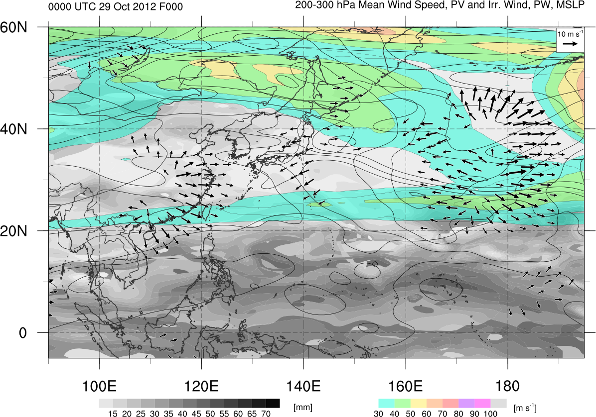
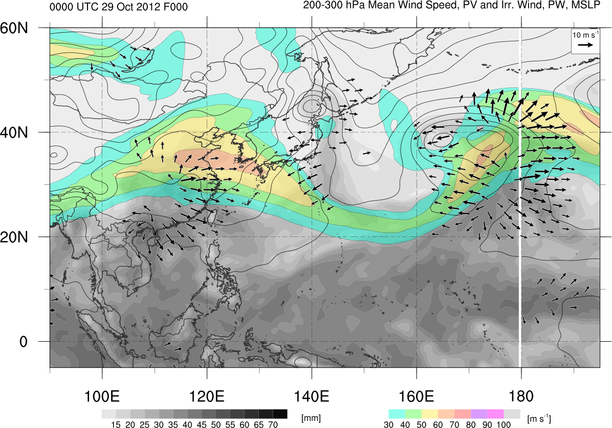
linked to a pair of smaller, regional maps that demonstrate the issue at
hand - one plotted correctly but without a cyclic point, and one with
cyclic points turned on where data is distorted.
If further tinkering with my script is necessary, I can upload the script
(easy to set up for a different machine) and data file that could be used
to test - just let me know. Finally, I've tested this on the 6.1.0-beta and
the just-uploaded full 6.1.0 with the same effects. Any advice? Thanks...
Images:
http://www.atmos.albany.edu/student/kgriffin/tmp/jet_mslp_irrwind_wpac_568272.png
http://www.atmos.albany.edu/student/kgriffin/tmp/jet_mslp_irrwind_wpac_568272_nocyclic.png
Kyle
p.s. Variables below are lonFlipped before plotting and thus the cyclic
point is not being added at 180 in linked maps, despite being lon=0..359.5
below. Same errors occur with/without lonFlip.
printVarSummary statements:
Variable: jet
Type: float
Total Size: 1039680 bytes
259920 values
Number of Dimensions: 3
Dimensions and sizes: [time | 1] x [lat | 361] x [lon | 720]
Coordinates:
time: [77733.75..77733.75]
lat: [-90..90]
lon: [ 0..359.5]
Number Of Attributes: 1
_FillValue : 9.96921e+36
Variable: pw
Type: float
Total Size: 1039680 bytes
259920 values
Number of Dimensions: 3
Dimensions and sizes: [time | 1] x [lat | 361] x [lon | 720]
Coordinates:
time: [77733.75..77733.75]
lat: [-90..90]
lon: [ 0..359.5]
Number Of Attributes: 1
_FillValue : 9.96921e+36
Variable: pmsl
Type: float
Total Size: 1039680 bytes
259920 values
Number of Dimensions: 3
Dimensions and sizes: [time | 1] x [lat | 361] x [lon | 720]
Coordinates:
time: [77733.75..77733.75]
lat: [-90..90]
lon: [ 0..359.5]
Number Of Attributes: 1
_FillValue : 9.96921e+36
Variable: irr
Type: float
Total Size: 2079360 bytes
519840 values
Number of Dimensions: 4
Dimensions and sizes: [component | 2] x [time | 1] x [lat | 361] x [lon |
720]
Coordinates:
component: [0..1]
time: [77733.75..77733.75]
lat: [-90..90]
lon: [ 0..359.5]
Number Of Attributes: 4
units : m/s
long_name : divergent zonal [0] and meridional [1] winds
average_op_ncl : dim_avg_n over dimension(s): pres_lev
_FillValue : 9.96921e+36
----------------------------------------
Kyle S. Griffin
Department of Atmospheric and Oceanic Sciences
University of Wisconsin - Madison
1225 W Dayton St, Madison, WI 53706
Room 1421 Email: ksgriffin2@wisc.edu
_______________________________________________
ncl-talk mailing list
List instructions, subscriber options, unsubscribe:
http://mailman.ucar.edu/mailman/listinfo/ncl-talk
Received on Mon Oct 29 08:31:55 2012
This archive was generated by hypermail 2.1.8 : Wed Oct 31 2012 - 09:14:12 MDT