Date: Thu Aug 29 2013 - 15:57:40 MDT
Hello,
I have plotted a full CALIPSO scan. However, I now want to plot only a
certain region of it.
What makes this equally as challenging is that the latitude and longitude
coordinates at the x-axis must also reflect that change.
I have attempted to use the 'ind' function to extract the wanted latitude
and longitude parts. I have also used 'region_ind'.
I then placed the subscripts within the formatted parts (xlabel) and the
backscatter (back), but that has been unsuccessful. The formatting becomes
disrupted and the plot just remains the same.
I then understood that the backscatter information actually doesn't possess
latitude and longitude information. I have attempted to combine this
information, but I have been unsuccessful.
I have also attempted to use XBValues, and that has worked... but it gives
me a really awful, inaccurate, "smeared" plot.
There is a better way to do this... what am I missing?
Thank you in advance.
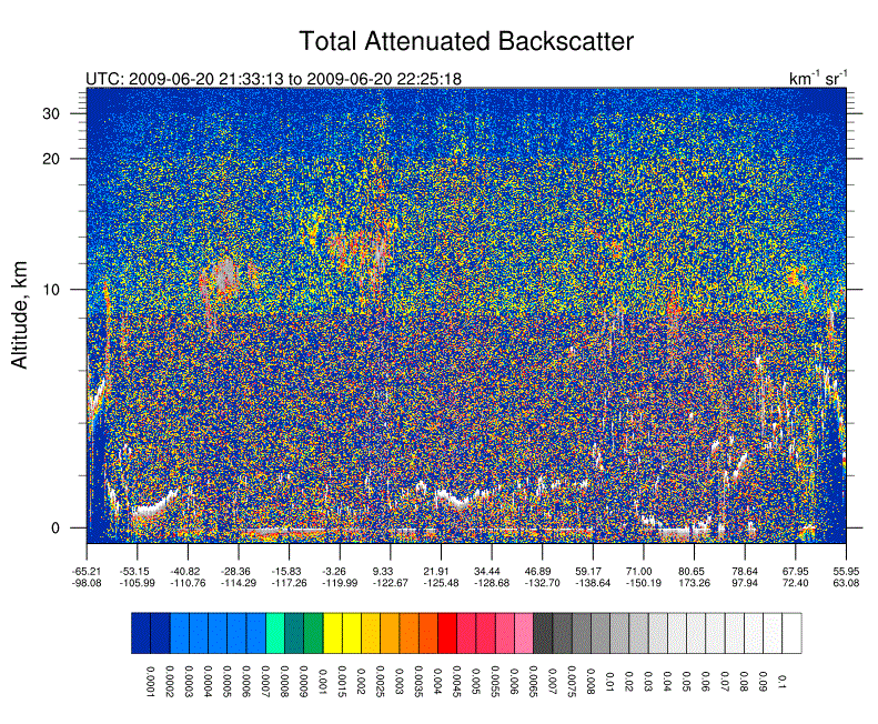
The code is below. I locate the problem within the comments. I have also
attached a picture of the full CALIPSO scan for reference.
I posted earlier in regard to a similar matter, which has been solved. I
apologize for annoyingly posting back-to-back questions; CALIPSO has been
giving me trouble recently.
Code:
;**************************************************
; This will plot CALIPSO data for your domain
; Author: Cory Wolff from UCAR (thank him in thesis!), edits by J. Madden
;**************************************************
load "$NCARG_ROOT/lib/ncarg/nclscripts/csm/gsn_code.ncl"
load "$NCARG_ROOT/lib/ncarg/nclscripts/csm/gsn_csm.ncl"
load "$NCARG_ROOT/lib/ncarg/nclscripts/csm/contributed.ncl"
load "$NCARG_ROOT/lib/ncarg/nclscripts/csm/shea_util.ncl"
load "$NCARG_ROOT/lib/ncarg/nclscripts/contrib/ut_string.ncl"
load "color_map.ncl"
;**************************************************
begin
; --- Read Calipso Data ------------;
f =
addfile("/import/archive/u1/uaf/jmmadden/WILDFIRE2009/CALIPSOdata/HDF/CAL_LID_L1-ValStage1-V3-01.2009-06-20T21-33-08ZD.hdf","r")
back1 = f->Total_Attenuated_Backscatter_532
dims = getvardims(back1)
; Reverse the vertical array
back1 = back1(:,::-1)
; Reorder using string dimension names
back = back1($dims(1)$|:,$dims(0)$|:)
back@_FillValue = -9999
back@units = "km~S~-1~NN~ sr~S~-1~NN~"
; Get the lat and lon arrays for the x-axis
lat = f->Latitude
lon = f->Longitude
; However you also want the values within your own domain. Input max and
min lat/lon values.
minlat = 63.696
maxlat = 67.4163
minlon = -154.725
maxlon = -142.875
; THE PROBLEM IS HERE. Coupling latitude and longitude changes with the
backscatter information.
; ii = ind((lat.ge.minlat) .and. (lat.le.maxlat) .and. (lon.ge.minlon)
.and. (lon.le.maxlon)) ; this disrupts the formatting
; ii = region_ind(lat,lon,minlat,maxlat,minlon,maxlon) ;this gives odd
lat/lon values
xlabel = sprintf("%.2f",lat)+"~C~"+sprintf("%.2f",lon) ;for full
CALIPSO plot
; xlabel = sprintf("%.2f",ii)+"~C~"+sprintf("%.2f",ii)
; Work with the time fields to get a valid time string
time = f->Profile_Time
time@units = "seconds since 1993-01-01 00:00"
tstring = ut_string(time(:,0), "%Y-%N-%D %H:%M:%S")
tstring2 = ut_string(time(:,0), "%Y-%N-%D_%H-%M-%S")
; Set stride intervals for x-axis
stride = dimsizes(tstring)/15
; stride = dimsizes(tstring)
; Get the altitude values.
hgt = asciiread("lidar_altitudes.txt", -1, "float")
hgt = hgt(::-1) ; Reverse this array too
hgt!0 = "hgt"
hgt@long_name = "Altitude, km"
hgt@units = "km"
; Assign new dimensions and attributes
back!0 = "hgt"
back&hgt = hgt
xcoord = ispan(0,dimsizes(lat(:,0)) - 1,1) ; to solve non-monotonic
problem
back!1 = "xcoord"
back&xcoord = xcoord
;*************************
; create plot
;*************************
wks = gsn_open_wks("x11", "backscatter")
cmap = new((/36,3/), float)
gen_backscatter_cmap(cmap)
setvalues wks
"wkColorMap" : cmap
end setvalues
setvalues NhlGetWorkspaceObjectId()
"wsMaximumSize": 300000000
end setvalues
res = True
res@cnFillOn = True ; color plot desired
res@cnLinesOn = False
res@cnRasterModeOn = True
res@gsnSpreadColors = True ; use all colors
res@gsnAddCyclic = False
res@gsnMaximize = True
res@gsnLeftString = "UTC: "+tstring(0)+" to
"+tstring(dimsizes(tstring)-1)
res@tiMainString = "Total Attenuated Backscatter"
res@tiMainFontHeightF = 0.025
res@tiYAxisFontHeightF = 0.02
res@cnLevelSelectionMode = "ExplicitLevels"
res@cnLevels =
(/0.0001,0.0002,0.0003,0.0004,0.0005,0.0006,0.0007,0.0008,0.0009,0.001,0.0015,0.002,0.0025,0.003,0.0035,0.004,0.0045,0.005,0.0055,0.006,0.0065,0.007,0.0075,0.008,0.01,0.02,0.03,0.04,0.05,0.06,0.07,0.08,0.09,0.1/)
res@tmXTOn = False
res@tmXBMode = "Explicit"
res@tmXBValues = xcoord(::stride)
res@tmXBLabels = xlabel(::stride,0)
res@tmXBLabelFontHeightF = 0.01
res@lbLabelFontHeightF = 0.01
res@lbLabelAngleF = -90.0
res@vpWidthF = 1.0
res@gsnDraw = True
res@gsnFrame = False
plot = gsn_csm_contour(wks,back,res)
frame(wks)
end
--
*Mike Madden
*
*jmmadden@alaska.edu
*
*Office:  (907) 474-7618
*
---------------------------------------------------------------------
* "Buy the ticket, take the ride."  Hunter S. Thompson
*
_______________________________________________
ncl-talk mailing list
List instructions, subscriber options, unsubscribe:
http://mailman.ucar.edu/mailman/listinfo/ncl-talk