Date: Mon, 26 Feb 2007 17:09:58 -0700
Hi!
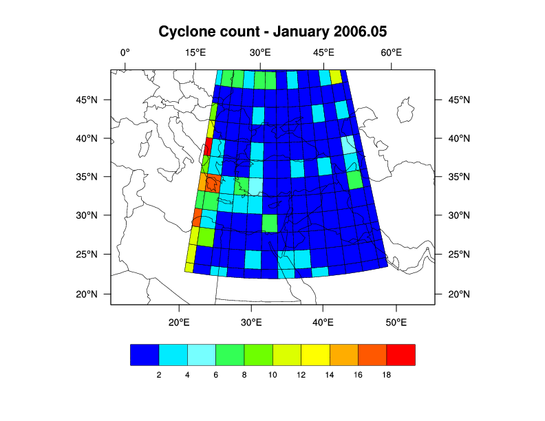
I am trying to draw a raster plot of cyclone counts defined on a uniform
lat/lon grid on a map on a Lambert projection. The uniform cyclone
count grid is plotted in the right place, but only half of the "squares"
at the edge of the domain are drawn. Is there a resource parameter I
can use to disable this behavior?
The documentation states that "If the data grid is defined using cell
edges, the cell boundaries are obtained explicitly from the coordinate
arrays. " I think this is how I might solve my problem... But, how do I
define the data array using the cell edge?
I have attached my resulting image and a snip of the code is below.
Any help will be greatly appreciated!
Thanks,
Andrea
lat1dg = fspan(25.,55.,13)
lat1dg_at_long_name = "latitude"
lat1dg_at_units = "degrees north"
lon1dg = fspan(20.,50.,13)
lon1dg_at_long_name = "longitude"
lon1dg_at_units = "degrees east"
ncycl = new((/13,13/),"float")
ncycl = 0.
ncycl!0 = "lat"
ncycl&lat = lat1dg
ncycl!1 = "lon"
ncycl&lon = lon1dg
...
res_at_cnFillOn = True ; turn on color fill
res_at_cnFillMode = "CellFill"
res_at_cnCellFillEdgeColor = 1
res_at_gsnAddCyclic = False
res_at_gsnSpreadColors = True ; use full range of
colors
res_at_cnLinesOn = False
res_at_cnLineLabelsOn = False
res_at_gsnMaximize = True
res_at_tiMainString = "Cyclone count - January "+YearRes
plot = gsn_csm_contour_map(wks,ncycl,res)
--
----------------------------------------------------------------
Andrea N. Hahmann, Ph.D.
Research Applications Laboratory
Natl. Center for Atmospheric Research      Phone: 1-303-497-8383
PO BOX 3000                                Fax:   1-303-497-8401
Boulder, CO 80301                          hahmann_at_ucar.edu
----------------------------------------------------------------
_______________________________________________
ncl-talk mailing list
ncl-talk_at_ucar.edu
http://mailman.ucar.edu/mailman/listinfo/ncl-talk