Hi Mary,
It does indeed fix the problem. I remember that thought occurred to me
earlier, but I never got around to trying it. Will fix my data processing
to include the relevant units. Thanks for the fix!
Kyle
----------------------------------------
Kyle S. Griffin
Department of Atmospheric and Oceanic Sciences
University of Wisconsin - Madison
1225 W Dayton St, Madison, WI 53706
Room 1421 Email: ksgriffin2@wisc.edu
On Mon, Oct 29, 2012 at 4:48 PM, Mary Haley <haley@ucar.edu> wrote:
> Kyle,
>
> I think the problem might be that your lat/lon coordinate arrays don't
> have a "units" attribute.
>
> Try fixing all of your arrays to have the correct units, and let me know
> if this doesn't fix the problem:
>
> jet&lat@units = "degrees_north"
> jet&lon@units = "degrees_east"
> pw&lat@units = "degrees_north"
> pw&lon@units = "degrees_east"
> pmsl&lat@units = "degrees_north"
> pmsl&lon@units = "degrees_east"
> irr&lat@units = "degrees_north"
> irr&lon@units = "degrees_east"
>
> I'm not sure why gsnAddCyclic fails if a units is not specified, but I
> want to first verify that the above works for you. It seemed to work for me
> on the script and data you provided me with.
>
> --Mary
>
> On Oct 29, 2012, at 8:31 AM, Kyle Griffin wrote:
>
> > Hi all,
> >
> > In attempting to use gsnAddCyclic = True in a script, I have discovered
> that it does not seem to function properly with the data as I am trying to
> plot it. I've simplified down several portions of the script and it does
> appear to boil down to this resource.
> >
> > The data I'm plotting has printVarSummary statements that I've linked
> below represent each of the variables being plotted in the script (I've
> turned a couple off for simplicity's sake here as well). While the
> addCyclic documentation suggests it should be "True" by default anytime in
> can detect a cyclic dataset being plotted, this does not appear to be the
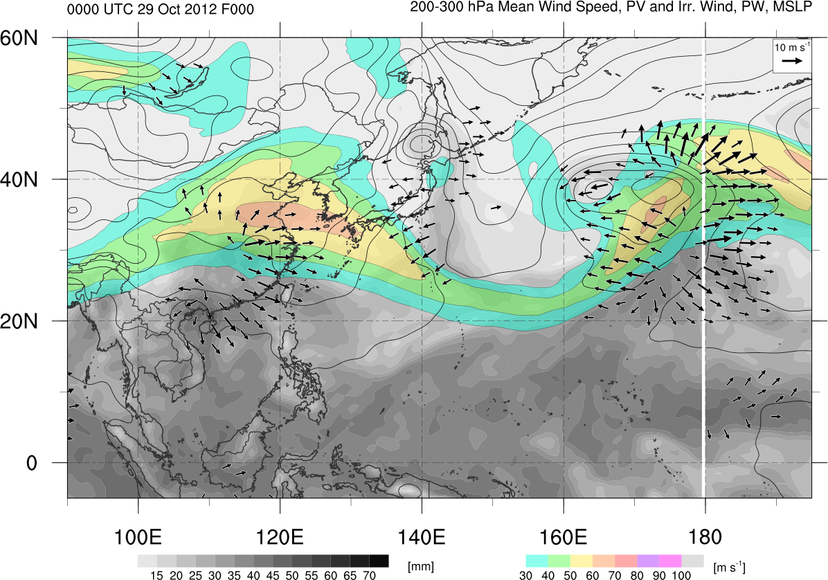
> case. Further, when it is set to true, it distorts the data and plots it at
> incorrect coordinates - earlier tests showed a full set of longitudes would
> be plotted without distortion, but shifted ~90 degrees to the west. I've
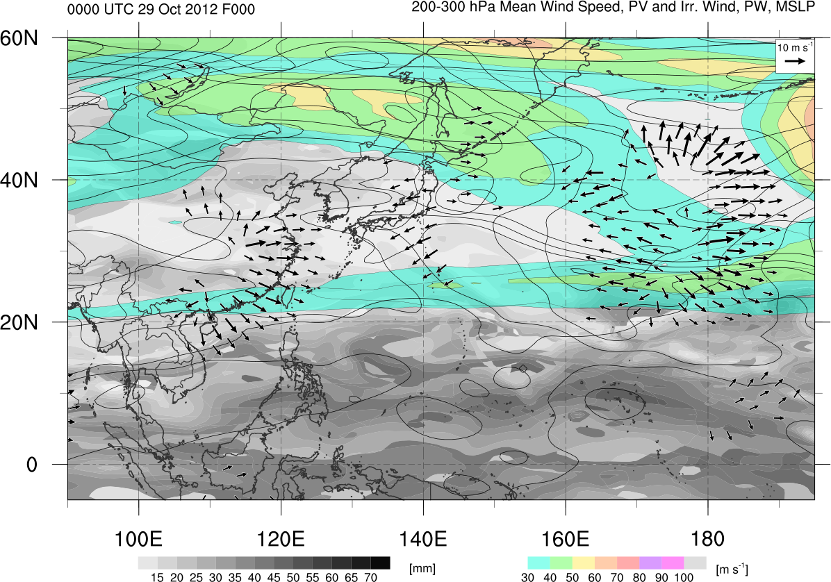
> linked to a pair of smaller, regional maps that demonstrate the issue at
> hand - one plotted correctly but without a cyclic point, and one with
> cyclic points turned on where data is distorted.
> >
> > If further tinkering with my script is necessary, I can upload the
> script (easy to set up for a different machine) and data file that could be
> used to test - just let me know. Finally, I've tested this on the
> 6.1.0-beta and the just-uploaded full 6.1.0 with the same effects. Any
> advice? Thanks...
> >
> > Images:
> >
> http://www.atmos.albany.edu/student/kgriffin/tmp/jet_mslp_irrwind_wpac_568272.png
> >
> http://www.atmos.albany.edu/student/kgriffin/tmp/jet_mslp_irrwind_wpac_568272_nocyclic.png
> >
> >
> > Kyle
> >
> > p.s. Variables below are lonFlipped before plotting and thus the cyclic
> point is not being added at 180 in linked maps, despite being lon=0..359.5
> below. Same errors occur with/without lonFlip.
> >
> > printVarSummary statements:
> >
> > Variable: jet
> > Type: float
> > Total Size: 1039680 bytes
> > 259920 values
> > Number of Dimensions: 3
> > Dimensions and sizes: [time | 1] x [lat | 361] x [lon | 720]
> > Coordinates:
> > time: [77733.75..77733.75]
> > lat: [-90..90]
> > lon: [ 0..359.5]
> > Number Of Attributes: 1
> > _FillValue : 9.96921e+36
> >
> > Variable: pw
> > Type: float
> > Total Size: 1039680 bytes
> > 259920 values
> > Number of Dimensions: 3
> > Dimensions and sizes: [time | 1] x [lat | 361] x [lon | 720]
> > Coordinates:
> > time: [77733.75..77733.75]
> > lat: [-90..90]
> > lon: [ 0..359.5]
> > Number Of Attributes: 1
> > _FillValue : 9.96921e+36
> >
> > Variable: pmsl
> > Type: float
> > Total Size: 1039680 bytes
> > 259920 values
> > Number of Dimensions: 3
> > Dimensions and sizes: [time | 1] x [lat | 361] x [lon | 720]
> > Coordinates:
> > time: [77733.75..77733.75]
> > lat: [-90..90]
> > lon: [ 0..359.5]
> > Number Of Attributes: 1
> > _FillValue : 9.96921e+36
> >
> > Variable: irr
> > Type: float
> > Total Size: 2079360 bytes
> > 519840 values
> > Number of Dimensions: 4
> > Dimensions and sizes: [component | 2] x [time | 1] x [lat | 361] x [lon
> | 720]
> > Coordinates:
> > component: [0..1]
> > time: [77733.75..77733.75]
> > lat: [-90..90]
> > lon: [ 0..359.5]
> > Number Of Attributes: 4
> > units : m/s
> > long_name : divergent zonal [0] and meridional [1] winds
> > average_op_ncl : dim_avg_n over dimension(s): pres_lev
> > _FillValue : 9.96921e+36
> > ----------------------------------------
> > Kyle S. Griffin
> > Department of Atmospheric and Oceanic Sciences
> > University of Wisconsin - Madison
> > 1225 W Dayton St, Madison, WI 53706
> > Room 1421 Email: ksgriffin2@wisc.edu
> >
> > _______________________________________________
> > ncl-talk mailing list
> > List instructions, subscriber options, unsubscribe:
> > http://mailman.ucar.edu/mailman/listinfo/ncl-talk
>
>
_______________________________________________
ncl-talk mailing list
List instructions, subscriber options, unsubscribe:
http://mailman.ucar.edu/mailman/listinfo/ncl-talk
Received on Mon Oct 29 16:48:40 2012
This archive was generated by hypermail 2.1.8 : Wed Oct 31 2012 - 09:14:12 MDT