Date: Wed Nov 28 2012 - 11:50:15 MST
Dear NCL talk
help,
I would like to
kindly ask for some advice regarding the plotting of rotated lat-lon
output. I am currently trying to plot the output from a rotated
lat-lon grid using NCL...
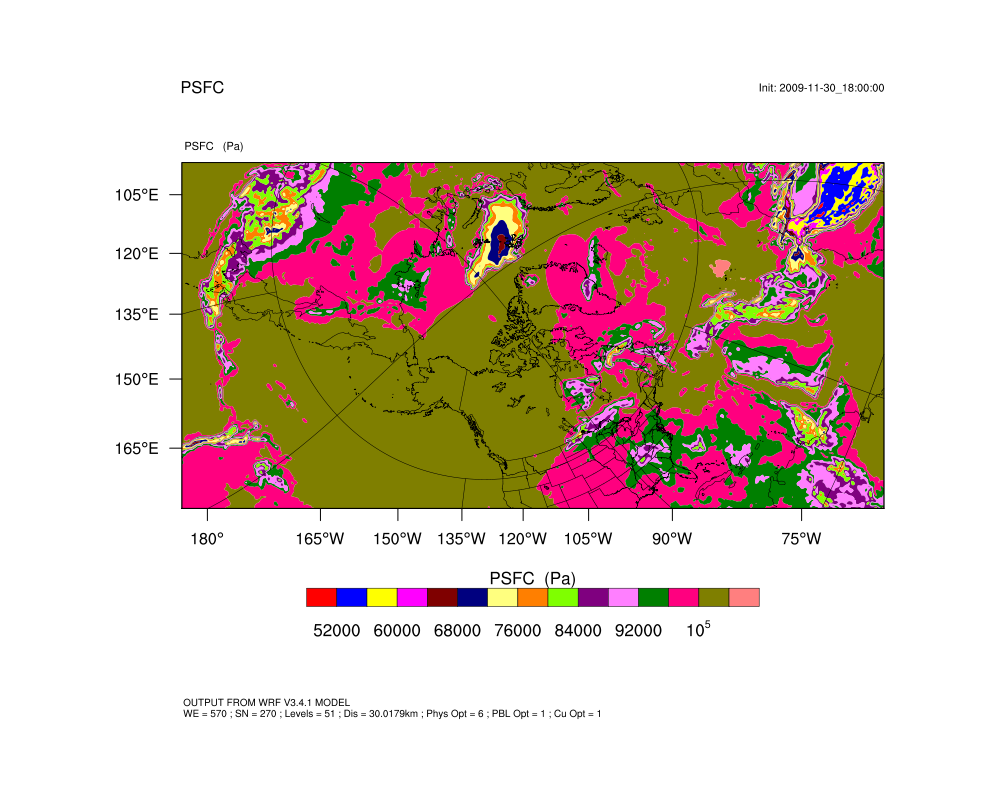
When I make the
contour plot of my variable (psfc), all of the contoured data appears
where I expect and want it to be, the land-sea boundaries can even be
detected as the value of the variable changes. So everything seems
fine in that respect.
However, when I
try to plot the national/geographical borders using a map overlay,
the borders are all in the wrong places. Please see the attached
image, in which it is clearly visible.
The variable I
am plotting (PSFC) is made up of (time, west_east, south_north), with
west_east and south_north corresponding to a point on the
computational grid (i.e. they're defined by a lat and lon from the
computational grid).
I also have 2D
arrays (XLAT and XLONG) giving the geographical latitude and
longitude for every point on the computational grid. I tried to use
these to plot the geographical boundaries in the correct location,
but sadly to no avail.
I have looked
through the NCL talk archives and on the NCL website, but
unfortunately nothing I've tried has worked so far.
I'll include my
script below and also attach a copy of the output from an
ncl_filedump on my data. You'll notice in the script below that lots
of the map options are commented out; that's because several tries
showed them to make no difference whatsoever to the plot I received,
whether they were included or commented out (I did try plotting with
them uncommented though, in several different combinations). The only
one of those options that did make a difference was setting
mpres@mpCenterLatF = a@CEN_LAT. But that only changed it from one
incorrect plot to another incorrect one, albeit the new looks
slightly better (attached).
If you had any guidance as to where I might be going wrong I would be
most appreciative.
Many thanks for any advice,
Dave.
----------------------SCRIPT-----------------------------
; Basic script for plotting model output
load "$NCARG_ROOT/lib/ncarg/nclscripts/csm/gsn_code.ncl"
load "$NCARG_ROOT/lib/ncarg/nclscripts/csm/gsn_csm.ncl"
load "$NCARG_ROOT/lib/ncarg/nclscripts/wrf/WRFUserARW.ncl"
load "$NCARG_ROOT/lib/ncarg/nclscripts/csm/contributed.ncl"
begin
a = addfile("wrfout_d01_2009-12-01_00:00:00.nc","r")
wks = gsn_open_wks("x11","PSFC")
;---------------------------------------------------------------
; Set basic resources
res = True
res@MainTitle = "PSFC" ; Give a main title
pltres = True ; Plotting resources
mpres = True ; Map resources
;---------------------------------------------------------------
; Get variables
;---1. WRF------------------
psfc = a->PSFC(0,:,:)
psfc_size = dimsizes(psfc(:,:))
print("dimsizes(psfc) = " + psfc_size)
;---2. Lat/Lon arrays-------
lat2d = a->XLAT(0,:,:)
printVarSummary(lat2d)
lon2d = a->XLONG(0,:,:)
printVarSummary(lon2d)
;--------------------------------------------------------------
; Plotting options
opts = res ; Add basic resources
opts@FieldTitle = "PSFC"
opts@cnFillOn = True ; Shaded plot
opts@gsnSpreadColorEnd = -8 ;
contour_psfc = wrf_contour(a,wks,psfc,opts)
; Set some map options
; mpres@tfDoNDCOverlay= True
; pltres@sfXArray = lon2d
; pltres@sfYArray = lat2d
; pltres@LatLonOverlay = True
; mpres@mpCenterLonF = a@CEN_LON ;= -16.84654
mpres@mpCenterLatF = a@CEN_LAT ;= 53.4331
; mpres@mpProjection = "CylindricalEquidistant"
; mpres@mpLimitMode = "Corners"
; mpres@mpLeftCornerLatF = lat2d(0,0) ; bottom left
; mpres@mpLeftCornerLonF = lon2d(0,0) ; bottom left
; mpres@mpRightCornerLatF= lat2d(268,568) ; top right
; mpres@mpRightCornerLonF= lon2d(268,568) ; top right
mpres@mpGeophysicalLineColor = "Black"
mpres@mpGridLineColor = "Black"
mpres@mpLimbLineColor = "Black"
mpres@mpNationalLineColor = "Black"
mpres@mpUSStateLineColor = "Black"
mpres@mpPerimLineColor = "Black"
mpres@mpGeophysicalLineThicknessF = 1.0
mpres@mpGridLineThicknessF = 1.0
mpres@mpLimbLineThicknessF = 1.0
mpres@mpNationalLineThicknessF = 1.0
mpres@mpUSStateLineThicknessF = 1.0
; Namelist map projection information:
; map_proj : "lat-lon" (cylindrical equidistant)
; ref_lat : 88.5 (geographical lat of grid point (ref_x,ref_y)
; ref_lon : -5.0 (geographical lon of grid point (ref_x,ref_y)
; ref_x : 285 (total x grid points = 570)
; ref_y : 265 (total y grid points = 270)
; pole_lat : 35.0 (lat of geog N hem pole on comp grid)
; pole_lon : 180.0(lon of geog N hem pole on comp grid)
; stand_lon: 17.5 (rotation about geographic poles)
; MAKE PLOTS
plot = wrf_map_overlays(a,wks,(/contour_psfc/),pltres,mpres)
delete(res)
end
Copyright (C) 1995-2010 - All Rights Reserved
University Corporation for Atmospheric Research
NCAR Command Language Version 5.2.1
The use of this software is governed by a License Agreement.
See http://www.ncl.ucar.edu/ for more details.
Variable: f (file variable)
filename: wrfout_d01_2009-12-01_00:00:00
path: wrfout_d01_2009-12-01_00:00:00
file global attributes:
TITLE : OUTPUT FROM WRF V3.4.1 MODEL
START_DATE : 2009-11-30_18:00:00
SIMULATION_START_DATE : 2009-11-01_00:00:00
WEST-EAST_GRID_DIMENSION : 570
SOUTH-NORTH_GRID_DIMENSION : 270
BOTTOM-TOP_GRID_DIMENSION : 51
DX : 30017.92
DY : 30017.92
GRIDTYPE : C
DIFF_OPT : 1
KM_OPT : 4
DAMP_OPT : 0
DAMPCOEF : 0.2
KHDIF : 0
KVDIF : 0
MP_PHYSICS : 6
RA_LW_PHYSICS : 3
RA_SW_PHYSICS : 3
SF_SFCLAY_PHYSICS : 1
SF_SURFACE_PHYSICS : 2
BL_PBL_PHYSICS : 1
CU_PHYSICS : 1
SURFACE_INPUT_SOURCE : 1
SST_UPDATE : 1
GRID_FDDA : 0
GFDDA_INTERVAL_M : 0
GFDDA_END_H : 0
GRID_SFDDA : 0
SGFDDA_INTERVAL_M : 0
SGFDDA_END_H : 0
HYPSOMETRIC_OPT : 2
SF_URBAN_PHYSICS : 0
SHCU_PHYSICS : 0
MFSHCONV : 0
FEEDBACK : 0
SMOOTH_OPTION : 0
SWRAD_SCAT : 1
W_DAMPING : 0
MOIST_ADV_OPT : 1
SCALAR_ADV_OPT : 1
TKE_ADV_OPT : 1
DIFF_6TH_OPT : 0
DIFF_6TH_FACTOR : 0.12
OBS_NUDGE_OPT : 0
BUCKET_MM : 100
BUCKET_J : 1e+09
PREC_ACC_DT : 360
OMLCALL : 0
ISFTCFLX : 0
ISHALLOW : 0
DFI_OPT : 0
WEST-EAST_PATCH_START_UNSTAG : 1
WEST-EAST_PATCH_END_UNSTAG : 569
WEST-EAST_PATCH_START_STAG : 1
WEST-EAST_PATCH_END_STAG : 570
SOUTH-NORTH_PATCH_START_UNSTAG : 1
SOUTH-NORTH_PATCH_END_UNSTAG : 269
SOUTH-NORTH_PATCH_START_STAG : 1
SOUTH-NORTH_PATCH_END_STAG : 270
BOTTOM-TOP_PATCH_START_UNSTAG : 1
BOTTOM-TOP_PATCH_END_UNSTAG : 50
BOTTOM-TOP_PATCH_START_STAG : 1
BOTTOM-TOP_PATCH_END_STAG : 51
GRID_ID : 1
PARENT_ID : 0
I_PARENT_START : 1
J_PARENT_START : 1
PARENT_GRID_RATIO : 1
DT : 90
CEN_LAT : 53.4331
CEN_LON : -16.84654
TRUELAT1 : 1e+20
TRUELAT2 : 1e+20
MOAD_CEN_LAT : 53.4331
STAND_LON : 17.5
POLE_LAT : 35
POLE_LON : 180
GMT : 0
JULYR : 2009
JULDAY : 305
MAP_PROJ : 6
MMINLU : USGS
NUM_LAND_CAT : 24
ISWATER : 16
ISLAKE : -1
ISICE : 24
ISURBAN : 1
ISOILWATER : 14
dimensions:
Time = 360 // unlimited
DateStrLen = 19
west_east = 569
south_north = 269
bottom_top = 50
bottom_top_stag = 51
soil_layers_stag = 4
west_east_stag = 570
south_north_stag = 270
variables:
character Times ( Time, DateStrLen )
float LU_INDEX ( Time, south_north, west_east )
FieldType : 104
MemoryOrder : XY
description : LAND USE CATEGORY
units :
stagger :
coordinates : XLONG XLAT
float ZNU ( Time, bottom_top )
FieldType : 104
MemoryOrder : Z
description : eta values on half (mass) levels
units :
stagger :
float ZNW ( Time, bottom_top_stag )
FieldType : 104
MemoryOrder : Z
description : eta values on full (w) levels
units :
stagger : Z
float ZS ( Time, soil_layers_stag )
FieldType : 104
MemoryOrder : Z
description : DEPTHS OF CENTERS OF SOIL LAYERS
units : m
stagger : Z
float DZS ( Time, soil_layers_stag )
FieldType : 104
MemoryOrder : Z
description : THICKNESSES OF SOIL LAYERS
units : m
stagger : Z
float VAR_SSO ( Time, south_north, west_east )
FieldType : 104
MemoryOrder : XY
description : variance of subgrid-scale orography
units : m2
stagger :
coordinates : XLONG XLAT
float LAP_HGT ( Time, south_north, west_east )
FieldType : 104
MemoryOrder : XY
description : Laplacian of orography
units : m
stagger :
coordinates : XLONG XLAT
float U ( Time, bottom_top, south_north, west_east_stag )
FieldType : 104
MemoryOrder : XYZ
description : x-wind component
units : m s-1
stagger : X
coordinates : XLONG_U XLAT_U
float V ( Time, bottom_top, south_north_stag, west_east )
FieldType : 104
MemoryOrder : XYZ
description : y-wind component
units : m s-1
stagger : Y
coordinates : XLONG_V XLAT_V
float W ( Time, bottom_top_stag, south_north, west_east )
FieldType : 104
MemoryOrder : XYZ
description : z-wind component
units : m s-1
stagger : Z
coordinates : XLONG XLAT
float PH ( Time, bottom_top_stag, south_north, west_east )
FieldType : 104
MemoryOrder : XYZ
description : perturbation geopotential
units : m2 s-2
stagger : Z
coordinates : XLONG XLAT
float PHB ( Time, bottom_top_stag, south_north, west_east )
FieldType : 104
MemoryOrder : XYZ
description : base-state geopotential
units : m2 s-2
stagger : Z
coordinates : XLONG XLAT
float T ( Time, bottom_top, south_north, west_east )
FieldType : 104
MemoryOrder : XYZ
description : perturbation potential temperature (theta-t0)
units : K
stagger :
coordinates : XLONG XLAT
float HFX_FORCE ( Time )
FieldType : 104
MemoryOrder : 0
description : SCM ideal surface sensible heat flux
units : W m-2
stagger :
float LH_FORCE ( Time )
FieldType : 104
MemoryOrder : 0
description : SCM ideal surface latent heat flux
units : W m-2
stagger :
float TSK_FORCE ( Time )
FieldType : 104
MemoryOrder : 0
description : SCM ideal surface skin temperature
units : W m-2
stagger :
float HFX_FORCE_TEND ( Time )
FieldType : 104
MemoryOrder : 0
description : SCM ideal surface sensible heat flux tendency
units : W m-2 s-1
stagger :
float LH_FORCE_TEND ( Time )
FieldType : 104
MemoryOrder : 0
description : SCM ideal surface latent heat flux tendency
units : W m-2 s-1
stagger :
float TSK_FORCE_TEND ( Time )
FieldType : 104
MemoryOrder : 0
description : SCM ideal surface skin temperature tendency
units : W m-2 s-1
stagger :
float MU ( Time, south_north, west_east )
FieldType : 104
MemoryOrder : XY
description : perturbation dry air mass in column
units : Pa
stagger :
coordinates : XLONG XLAT
float MUB ( Time, south_north, west_east )
FieldType : 104
MemoryOrder : XY
description : base state dry air mass in column
units : Pa
stagger :
coordinates : XLONG XLAT
float NEST_POS ( Time, south_north, west_east )
FieldType : 104
MemoryOrder : XY
description : -
units : -
stagger :
coordinates : XLONG XLAT
float P ( Time, bottom_top, south_north, west_east )
FieldType : 104
MemoryOrder : XYZ
description : perturbation pressure
units : Pa
stagger :
coordinates : XLONG XLAT
float PB ( Time, bottom_top, south_north, west_east )
FieldType : 104
MemoryOrder : XYZ
description : BASE STATE PRESSURE
units : Pa
stagger :
coordinates : XLONG XLAT
float FNM ( Time, bottom_top )
FieldType : 104
MemoryOrder : Z
description : upper weight for vertical stretching
units :
stagger :
float FNP ( Time, bottom_top )
FieldType : 104
MemoryOrder : Z
description : lower weight for vertical stretching
units :
stagger :
float RDNW ( Time, bottom_top )
FieldType : 104
MemoryOrder : Z
description : inverse d(eta) values between full (w) levels
units :
stagger :
float RDN ( Time, bottom_top )
FieldType : 104
MemoryOrder : Z
description : inverse d(eta) values between half (mass) levels
units :
stagger :
float DNW ( Time, bottom_top )
FieldType : 104
MemoryOrder : Z
description : d(eta) values between full (w) levels
units :
stagger :
float DN ( Time, bottom_top )
FieldType : 104
MemoryOrder : Z
description : d(eta) values between half (mass) levels
units :
stagger :
float CFN ( Time )
FieldType : 104
MemoryOrder : 0
description : extrapolation constant
units :
stagger :
float CFN1 ( Time )
FieldType : 104
MemoryOrder : 0
description : extrapolation constant
units :
stagger :
float P_HYD ( Time, bottom_top, south_north, west_east )
FieldType : 104
MemoryOrder : XYZ
description : hydrostatic pressure
units : Pa
stagger :
coordinates : XLONG XLAT
float Q2 ( Time, south_north, west_east )
FieldType : 104
MemoryOrder : XY
description : QV at 2 M
units : kg kg-1
stagger :
coordinates : XLONG XLAT
float T2 ( Time, south_north, west_east )
FieldType : 104
MemoryOrder : XY
description : TEMP at 2 M
units : K
stagger :
coordinates : XLONG XLAT
float TH2 ( Time, south_north, west_east )
FieldType : 104
MemoryOrder : XY
description : POT TEMP at 2 M
units : K
stagger :
coordinates : XLONG XLAT
float PSFC ( Time, south_north, west_east )
FieldType : 104
MemoryOrder : XY
description : SFC PRESSURE
units : Pa
stagger :
coordinates : XLONG XLAT
float U10 ( Time, south_north, west_east )
FieldType : 104
MemoryOrder : XY
description : U at 10 M
units : m s-1
stagger :
coordinates : XLONG XLAT
float V10 ( Time, south_north, west_east )
FieldType : 104
MemoryOrder : XY
description : V at 10 M
units : m s-1
stagger :
coordinates : XLONG XLAT
float RDX ( Time )
FieldType : 104
MemoryOrder : 0
description : INVERSE X GRID LENGTH
units :
stagger :
float RDY ( Time )
FieldType : 104
MemoryOrder : 0
description : INVERSE Y GRID LENGTH
units :
stagger :
float RESM ( Time )
FieldType : 104
MemoryOrder : 0
description : TIME WEIGHT CONSTANT FOR SMALL STEPS
units :
stagger :
float ZETATOP ( Time )
FieldType : 104
MemoryOrder : 0
description : ZETA AT MODEL TOP
units :
stagger :
float CF1 ( Time )
FieldType : 104
MemoryOrder : 0
description : 2nd order extrapolation constant
units :
stagger :
float CF2 ( Time )
FieldType : 104
MemoryOrder : 0
description : 2nd order extrapolation constant
units :
stagger :
float CF3 ( Time )
FieldType : 104
MemoryOrder : 0
description : 2nd order extrapolation constant
units :
stagger :
integer ITIMESTEP ( Time )
FieldType : 106
MemoryOrder : 0
description :
units :
stagger :
float XTIME ( Time )
FieldType : 104
MemoryOrder : 0
description : minutes since simulation start
units :
stagger :
float QVAPOR ( Time, bottom_top, south_north, west_east )
FieldType : 104
MemoryOrder : XYZ
description : Water vapor mixing ratio
units : kg kg-1
stagger :
coordinates : XLONG XLAT
float QCLOUD ( Time, bottom_top, south_north, west_east )
FieldType : 104
MemoryOrder : XYZ
description : Cloud water mixing ratio
units : kg kg-1
stagger :
coordinates : XLONG XLAT
float QRAIN ( Time, bottom_top, south_north, west_east )
FieldType : 104
MemoryOrder : XYZ
description : Rain water mixing ratio
units : kg kg-1
stagger :
coordinates : XLONG XLAT
float QICE ( Time, bottom_top, south_north, west_east )
FieldType : 104
MemoryOrder : XYZ
description : Ice mixing ratio
units : kg kg-1
stagger :
coordinates : XLONG XLAT
float QSNOW ( Time, bottom_top, south_north, west_east )
FieldType : 104
MemoryOrder : XYZ
description : Snow mixing ratio
units : kg kg-1
stagger :
coordinates : XLONG XLAT
float QGRAUP ( Time, bottom_top, south_north, west_east )
FieldType : 104
MemoryOrder : XYZ
description : Graupel mixing ratio
units : kg kg-1
stagger :
coordinates : XLONG XLAT
float SHDMAX ( Time, south_north, west_east )
FieldType : 104
MemoryOrder : XY
description : ANNUAL MAX VEG FRACTION
units :
stagger :
coordinates : XLONG XLAT
float SHDMIN ( Time, south_north, west_east )
FieldType : 104
MemoryOrder : XY
description : ANNUAL MIN VEG FRACTION
units :
stagger :
coordinates : XLONG XLAT
float SNOALB ( Time, south_north, west_east )
FieldType : 104
MemoryOrder : XY
description : ANNUAL MAX SNOW ALBEDO IN FRACTION
units :
stagger :
coordinates : XLONG XLAT
float TSLB ( Time, soil_layers_stag, south_north, west_east )
FieldType : 104
MemoryOrder : XYZ
description : SOIL TEMPERATURE
units : K
stagger : Z
coordinates : XLONG XLAT
float SMOIS ( Time, soil_layers_stag, south_north, west_east )
FieldType : 104
MemoryOrder : XYZ
description : SOIL MOISTURE
units : m3 m-3
stagger : Z
coordinates : XLONG XLAT
float SH2O ( Time, soil_layers_stag, south_north, west_east )
FieldType : 104
MemoryOrder : XYZ
description : SOIL LIQUID WATER
units : m3 m-3
stagger : Z
coordinates : XLONG XLAT
float SMCREL ( Time, soil_layers_stag, south_north, west_east )
FieldType : 104
MemoryOrder : XYZ
description : RELATIVE SOIL MOISTURE
units :
stagger : Z
coordinates : XLONG XLAT
float SEAICE ( Time, south_north, west_east )
FieldType : 104
MemoryOrder : XY
description : SEA ICE FLAG
units :
stagger :
coordinates : XLONG XLAT
float XICEM ( Time, south_north, west_east )
FieldType : 104
MemoryOrder : XY
description : SEA ICE FLAG (PREVIOUS STEP)
units :
stagger :
coordinates : XLONG XLAT
float SFROFF ( Time, south_north, west_east )
FieldType : 104
MemoryOrder : XY
description : SURFACE RUNOFF
units : mm
stagger :
coordinates : XLONG XLAT
float UDROFF ( Time, south_north, west_east )
FieldType : 104
MemoryOrder : XY
description : UNDERGROUND RUNOFF
units : mm
stagger :
coordinates : XLONG XLAT
integer IVGTYP ( Time, south_north, west_east )
FieldType : 106
MemoryOrder : XY
description : DOMINANT VEGETATION CATEGORY
units :
stagger :
coordinates : XLONG XLAT
integer ISLTYP ( Time, south_north, west_east )
FieldType : 106
MemoryOrder : XY
description : DOMINANT SOIL CATEGORY
units :
stagger :
coordinates : XLONG XLAT
float VEGFRA ( Time, south_north, west_east )
FieldType : 104
MemoryOrder : XY
description : VEGETATION FRACTION
units :
stagger :
coordinates : XLONG XLAT
float GRDFLX ( Time, south_north, west_east )
FieldType : 104
MemoryOrder : XY
description : GROUND HEAT FLUX
units : W m-2
stagger :
coordinates : XLONG XLAT
float ACGRDFLX ( Time, south_north, west_east )
FieldType : 104
MemoryOrder : XY
description : ACCUMULATED GROUND HEAT FLUX
units : J m-2
stagger :
coordinates : XLONG XLAT
float SNOW ( Time, south_north, west_east )
FieldType : 104
MemoryOrder : XY
description : SNOW WATER EQUIVALENT
units : kg m-2
stagger :
coordinates : XLONG XLAT
float SNOWH ( Time, south_north, west_east )
FieldType : 104
MemoryOrder : XY
description : PHYSICAL SNOW DEPTH
units : m
stagger :
coordinates : XLONG XLAT
float CANWAT ( Time, south_north, west_east )
FieldType : 104
MemoryOrder : XY
description : CANOPY WATER
units : kg m-2
stagger :
coordinates : XLONG XLAT
float SSTSK ( Time, south_north, west_east )
FieldType : 104
MemoryOrder : XY
description : SKIN SEA SURFACE TEMPERATURE
units : K
stagger :
coordinates : XLONG XLAT
float LAI ( Time, south_north, west_east )
FieldType : 104
MemoryOrder : XY
description : Leaf area index
units : area/area
stagger :
coordinates : XLONG XLAT
float MAPFAC_M ( Time, south_north, west_east )
FieldType : 104
MemoryOrder : XY
description : Map scale factor on mass grid
units :
stagger :
coordinates : XLONG XLAT
float MAPFAC_U ( Time, south_north, west_east_stag )
FieldType : 104
MemoryOrder : XY
description : Map scale factor on u-grid
units :
stagger : X
coordinates : XLONG_U XLAT_U
float MAPFAC_V ( Time, south_north_stag, west_east )
FieldType : 104
MemoryOrder : XY
description : Map scale factor on v-grid
units :
stagger : Y
coordinates : XLONG_V XLAT_V
float MAPFAC_MX ( Time, south_north, west_east )
FieldType : 104
MemoryOrder : XY
description : Map scale factor on mass grid, x direction
units :
stagger :
coordinates : XLONG XLAT
float MAPFAC_MY ( Time, south_north, west_east )
FieldType : 104
MemoryOrder : XY
description : Map scale factor on mass grid, y direction
units :
stagger :
coordinates : XLONG XLAT
float MAPFAC_UX ( Time, south_north, west_east_stag )
FieldType : 104
MemoryOrder : XY
description : Map scale factor on u-grid, x direction
units :
stagger : X
coordinates : XLONG_U XLAT_U
float MAPFAC_UY ( Time, south_north, west_east_stag )
FieldType : 104
MemoryOrder : XY
description : Map scale factor on u-grid, y direction
units :
stagger : X
coordinates : XLONG_U XLAT_U
float MAPFAC_VX ( Time, south_north_stag, west_east )
FieldType : 104
MemoryOrder : XY
description : Map scale factor on v-grid, x direction
units :
stagger : Y
coordinates : XLONG_V XLAT_V
float MF_VX_INV ( Time, south_north_stag, west_east )
FieldType : 104
MemoryOrder : XY
description : Inverse map scale factor on v-grid, x direction
units :
stagger : Y
coordinates : XLONG_V XLAT_V
float MAPFAC_VY ( Time, south_north_stag, west_east )
FieldType : 104
MemoryOrder : XY
description : Map scale factor on v-grid, y direction
units :
stagger : Y
coordinates : XLONG_V XLAT_V
float F ( Time, south_north, west_east )
FieldType : 104
MemoryOrder : XY
description : Coriolis sine latitude term
units : s-1
stagger :
coordinates : XLONG XLAT
float E ( Time, south_north, west_east )
FieldType : 104
MemoryOrder : XY
description : Coriolis cosine latitude term
units : s-1
stagger :
coordinates : XLONG XLAT
float SINALPHA ( Time, south_north, west_east )
FieldType : 104
MemoryOrder : XY
description : Local sine of map rotation
units :
stagger :
coordinates : XLONG XLAT
float COSALPHA ( Time, south_north, west_east )
FieldType : 104
MemoryOrder : XY
description : Local cosine of map rotation
units :
stagger :
coordinates : XLONG XLAT
float HGT ( Time, south_north, west_east )
FieldType : 104
MemoryOrder : XY
description : Terrain Height
units : m
stagger :
coordinates : XLONG XLAT
float TSK ( Time, south_north, west_east )
FieldType : 104
MemoryOrder : XY
description : SURFACE SKIN TEMPERATURE
units : K
stagger :
coordinates : XLONG XLAT
float P_TOP ( Time )
FieldType : 104
MemoryOrder : 0
description : PRESSURE TOP OF THE MODEL
units : Pa
stagger :
float T00 ( Time )
FieldType : 104
MemoryOrder : 0
description : BASE STATE TEMPERATURE
units : K
stagger :
float P00 ( Time )
FieldType : 104
MemoryOrder : 0
description : BASE STATE PRESURE
units : Pa
stagger :
float TLP ( Time )
FieldType : 104
MemoryOrder : 0
description : BASE STATE LAPSE RATE
units :
stagger :
float TISO ( Time )
FieldType : 104
MemoryOrder : 0
description : TEMP AT WHICH THE BASE T TURNS CONST
units : K
stagger :
float MAX_MSTFX ( Time )
FieldType : 104
MemoryOrder : 0
description : Max map factor in domain
units :
stagger :
float MAX_MSTFY ( Time )
FieldType : 104
MemoryOrder : 0
description : Max map factor in domain
units :
stagger :
float RAINC ( Time, south_north, west_east )
FieldType : 104
MemoryOrder : XY
description : ACCUMULATED TOTAL CUMULUS PRECIPITATION
units : mm
stagger :
coordinates : XLONG XLAT
float RAINSH ( Time, south_north, west_east )
FieldType : 104
MemoryOrder : XY
description : ACCUMULATED SHALLOW CUMULUS PRECIPITATION
units : mm
stagger :
coordinates : XLONG XLAT
float RAINNC ( Time, south_north, west_east )
FieldType : 104
MemoryOrder : XY
description : ACCUMULATED TOTAL GRID SCALE PRECIPITATION
units : mm
stagger :
coordinates : XLONG XLAT
integer I_RAINC ( Time, south_north, west_east )
FieldType : 106
MemoryOrder : XY
description : BUCKET FOR RAINC
units :
stagger :
coordinates : XLONG XLAT
integer I_RAINNC ( Time, south_north, west_east )
FieldType : 106
MemoryOrder : XY
description : BUCKET FOR RAINNC
units :
stagger :
coordinates : XLONG XLAT
float SNOWNC ( Time, south_north, west_east )
FieldType : 104
MemoryOrder : XY
description : ACCUMULATED TOTAL GRID SCALE SNOW AND ICE
units : mm
stagger :
coordinates : XLONG XLAT
float GRAUPELNC ( Time, south_north, west_east )
FieldType : 104
MemoryOrder : XY
description : ACCUMULATED TOTAL GRID SCALE GRAUPEL
units : mm
stagger :
coordinates : XLONG XLAT
float HAILNC ( Time, south_north, west_east )
FieldType : 104
MemoryOrder : XY
description : ACCUMULATED TOTAL GRID SCALE HAIL
units : mm
stagger :
coordinates : XLONG XLAT
float REFL_10CM ( Time, bottom_top, south_north, west_east )
FieldType : 104
MemoryOrder : XYZ
description : Radar reflectivity (lamda = 10 cm)
units : dBZ
stagger :
coordinates : XLONG XLAT
float CLDFRA ( Time, bottom_top, south_north, west_east )
FieldType : 104
MemoryOrder : XYZ
description : CLOUD FRACTION
units :
stagger :
coordinates : XLONG XLAT
float SWDOWN ( Time, south_north, west_east )
FieldType : 104
MemoryOrder : XY
description : DOWNWARD SHORT WAVE FLUX AT GROUND SURFACE
units : W m-2
stagger :
coordinates : XLONG XLAT
float GLW ( Time, south_north, west_east )
FieldType : 104
MemoryOrder : XY
description : DOWNWARD LONG WAVE FLUX AT GROUND SURFACE
units : W m-2
stagger :
coordinates : XLONG XLAT
float SWNORM ( Time, south_north, west_east )
FieldType : 104
MemoryOrder : XY
description : NORMAL SHORT WAVE FLUX AT GROUND SURFACE (SLOPE-DEPENDENT)
units : W m-2
stagger :
coordinates : XLONG XLAT
float ACSWUPT ( Time, south_north, west_east )
FieldType : 104
MemoryOrder : XY
description : ACCUMULATED UPWELLING SHORTWAVE FLUX AT TOP
units : J m-2
stagger :
coordinates : XLONG XLAT
float ACSWUPTC ( Time, south_north, west_east )
FieldType : 104
MemoryOrder : XY
description : ACCUMULATED UPWELLING CLEAR SKY SHORTWAVE FLUX AT TOP
units : J m-2
stagger :
coordinates : XLONG XLAT
float ACSWDNT ( Time, south_north, west_east )
FieldType : 104
MemoryOrder : XY
description : ACCUMULATED DOWNWELLING SHORTWAVE FLUX AT TOP
units : J m-2
stagger :
coordinates : XLONG XLAT
float ACSWDNTC ( Time, south_north, west_east )
FieldType : 104
MemoryOrder : XY
description : ACCUMULATED DOWNWELLING CLEAR SKY SHORTWAVE FLUX AT TOP
units : J m-2
stagger :
coordinates : XLONG XLAT
float ACSWUPB ( Time, south_north, west_east )
FieldType : 104
MemoryOrder : XY
description : ACCUMULATED UPWELLING SHORTWAVE FLUX AT BOTTOM
units : J m-2
stagger :
coordinates : XLONG XLAT
float ACSWUPBC ( Time, south_north, west_east )
FieldType : 104
MemoryOrder : XY
description : ACCUMULATED UPWELLING CLEAR SKY SHORTWAVE FLUX AT BOTTOM
units : J m-2
stagger :
coordinates : XLONG XLAT
float ACSWDNB ( Time, south_north, west_east )
FieldType : 104
MemoryOrder : XY
description : ACCUMULATED DOWNWELLING SHORTWAVE FLUX AT BOTTOM
units : J m-2
stagger :
coordinates : XLONG XLAT
float ACSWDNBC ( Time, south_north, west_east )
FieldType : 104
MemoryOrder : XY
description : ACCUMULATED DOWNWELLING CLEAR SKY SHORTWAVE FLUX AT BOTTOM
units : J m-2
stagger :
coordinates : XLONG XLAT
float ACLWUPT ( Time, south_north, west_east )
FieldType : 104
MemoryOrder : XY
description : ACCUMULATED UPWELLING LONGWAVE FLUX AT TOP
units : J m-2
stagger :
coordinates : XLONG XLAT
float ACLWUPTC ( Time, south_north, west_east )
FieldType : 104
MemoryOrder : XY
description : ACCUMULATED UPWELLING CLEAR SKY LONGWAVE FLUX AT TOP
units : J m-2
stagger :
coordinates : XLONG XLAT
float ACLWDNT ( Time, south_north, west_east )
FieldType : 104
MemoryOrder : XY
description : ACCUMULATED DOWNWELLING LONGWAVE FLUX AT TOP
units : J m-2
stagger :
coordinates : XLONG XLAT
float ACLWDNTC ( Time, south_north, west_east )
FieldType : 104
MemoryOrder : XY
description : ACCUMULATED DOWNWELLING CLEAR SKY LONGWAVE FLUX AT TOP
units : J m-2
stagger :
coordinates : XLONG XLAT
float ACLWUPB ( Time, south_north, west_east )
FieldType : 104
MemoryOrder : XY
description : ACCUMULATED UPWELLING LONGWAVE FLUX AT BOTTOM
units : J m-2
stagger :
coordinates : XLONG XLAT
float ACLWUPBC ( Time, south_north, west_east )
FieldType : 104
MemoryOrder : XY
description : ACCUMULATED UPWELLING CLEAR SKY LONGWAVE FLUX AT BOTTOM
units : J m-2
stagger :
coordinates : XLONG XLAT
float ACLWDNB ( Time, south_north, west_east )
FieldType : 104
MemoryOrder : XY
description : ACCUMULATED DOWNWELLING LONGWAVE FLUX AT BOTTOM
units : J m-2
stagger :
coordinates : XLONG XLAT
float ACLWDNBC ( Time, south_north, west_east )
FieldType : 104
MemoryOrder : XY
description : ACCUMULATED DOWNWELLING CLEAR SKY LONGWAVE FLUX AT BOTTOM
units : J m-2
stagger :
coordinates : XLONG XLAT
integer I_ACSWUPT ( Time, south_north, west_east )
FieldType : 106
MemoryOrder : XY
description : BUCKET FOR UPWELLING SHORTWAVE FLUX AT TOP
units : J m-2
stagger :
coordinates : XLONG XLAT
integer I_ACSWUPTC ( Time, south_north, west_east )
FieldType : 106
MemoryOrder : XY
description : BUCKET FOR UPWELLING CLEAR SKY SHORTWAVE FLUX AT TOP
units : J m-2
stagger :
coordinates : XLONG XLAT
integer I_ACSWDNT ( Time, south_north, west_east )
FieldType : 106
MemoryOrder : XY
description : BUCKET FOR DOWNWELLING SHORTWAVE FLUX AT TOP
units : J m-2
stagger :
coordinates : XLONG XLAT
integer I_ACSWDNTC ( Time, south_north, west_east )
FieldType : 106
MemoryOrder : XY
description : BUCKET FOR DOWNWELLING CLEAR SKY SHORTWAVE FLUX AT TOP
units : J m-2
stagger :
coordinates : XLONG XLAT
integer I_ACSWUPB ( Time, south_north, west_east )
FieldType : 106
MemoryOrder : XY
description : BUCKET FOR UPWELLING SHORTWAVE FLUX AT BOTTOM
units : J m-2
stagger :
coordinates : XLONG XLAT
integer I_ACSWUPBC ( Time, south_north, west_east )
FieldType : 106
MemoryOrder : XY
description : BUCKET FOR UPWELLING CLEAR SKY SHORTWAVE FLUX AT BOTTOM
units : J m-2
stagger :
coordinates : XLONG XLAT
integer I_ACSWDNB ( Time, south_north, west_east )
FieldType : 106
MemoryOrder : XY
description : BUCKET FOR DOWNWELLING SHORTWAVE FLUX AT BOTTOM
units : J m-2
stagger :
coordinates : XLONG XLAT
integer I_ACSWDNBC ( Time, south_north, west_east )
FieldType : 106
MemoryOrder : XY
description : BUCKET FOR DOWNWELLING CLEAR SKY SHORTWAVE FLUX AT BOTTOM
units : J m-2
stagger :
coordinates : XLONG XLAT
integer I_ACLWUPT ( Time, south_north, west_east )
FieldType : 106
MemoryOrder : XY
description : BUCKET FOR UPWELLING LONGWAVE FLUX AT TOP
units : J m-2
stagger :
coordinates : XLONG XLAT
integer I_ACLWUPTC ( Time, south_north, west_east )
FieldType : 106
MemoryOrder : XY
description : BUCKET FOR UPWELLING CLEAR SKY LONGWAVE FLUX AT TOP
units : J m-2
stagger :
coordinates : XLONG XLAT
integer I_ACLWDNT ( Time, south_north, west_east )
FieldType : 106
MemoryOrder : XY
description : BUCKET FOR DOWNWELLING LONGWAVE FLUX AT TOP
units : J m-2
stagger :
coordinates : XLONG XLAT
integer I_ACLWDNTC ( Time, south_north, west_east )
FieldType : 106
MemoryOrder : XY
description : BUCKET FOR DOWNWELLING CLEAR SKY LONGWAVE FLUX AT TOP
units : J m-2
stagger :
coordinates : XLONG XLAT
integer I_ACLWUPB ( Time, south_north, west_east )
FieldType : 106
MemoryOrder : XY
description : BUCKET FOR UPWELLING LONGWAVE FLUX AT BOTTOM
units : J m-2
stagger :
coordinates : XLONG XLAT
integer I_ACLWUPBC ( Time, south_north, west_east )
FieldType : 106
MemoryOrder : XY
description : BUCKET FOR UPWELLING CLEAR SKY LONGWAVE FLUX AT BOTTOM
units : J m-2
stagger :
coordinates : XLONG XLAT
integer I_ACLWDNB ( Time, south_north, west_east )
FieldType : 106
MemoryOrder : XY
description : BUCKET FOR DOWNWELLING LONGWAVE FLUX AT BOTTOM
units : J m-2
stagger :
coordinates : XLONG XLAT
integer I_ACLWDNBC ( Time, south_north, west_east )
FieldType : 106
MemoryOrder : XY
description : BUCKET FOR DOWNWELLING CLEAR SKY LONGWAVE FLUX AT BOTTOM
units : J m-2
stagger :
coordinates : XLONG XLAT
float SWUPT ( Time, south_north, west_east )
FieldType : 104
MemoryOrder : XY
description : INSTANTANEOUS UPWELLING SHORTWAVE FLUX AT TOP
units : W m-2
stagger :
coordinates : XLONG XLAT
float SWUPTC ( Time, south_north, west_east )
FieldType : 104
MemoryOrder : XY
description : INSTANTANEOUS UPWELLING CLEAR SKY SHORTWAVE FLUX AT TOP
units : W m-2
stagger :
coordinates : XLONG XLAT
float SWDNT ( Time, south_north, west_east )
FieldType : 104
MemoryOrder : XY
description : INSTANTANEOUS DOWNWELLING SHORTWAVE FLUX AT TOP
units : W m-2
stagger :
coordinates : XLONG XLAT
float SWDNTC ( Time, south_north, west_east )
FieldType : 104
MemoryOrder : XY
description : INSTANTANEOUS DOWNWELLING CLEAR SKY SHORTWAVE FLUX AT TOP
units : W m-2
stagger :
coordinates : XLONG XLAT
float SWUPB ( Time, south_north, west_east )
FieldType : 104
MemoryOrder : XY
description : INSTANTANEOUS UPWELLING SHORTWAVE FLUX AT BOTTOM
units : W m-2
stagger :
coordinates : XLONG XLAT
float SWUPBC ( Time, south_north, west_east )
FieldType : 104
MemoryOrder : XY
description : INSTANTANEOUS UPWELLING CLEAR SKY SHORTWAVE FLUX AT BOTTOM
units : W m-2
stagger :
coordinates : XLONG XLAT
float SWDNB ( Time, south_north, west_east )
FieldType : 104
MemoryOrder : XY
description : INSTANTANEOUS DOWNWELLING SHORTWAVE FLUX AT BOTTOM
units : W m-2
stagger :
coordinates : XLONG XLAT
float SWDNBC ( Time, south_north, west_east )
FieldType : 104
MemoryOrder : XY
description : INSTANTANEOUS DOWNWELLING CLEAR SKY SHORTWAVE FLUX AT BOTTOM
units : W m-2
stagger :
coordinates : XLONG XLAT
float LWUPT ( Time, south_north, west_east )
FieldType : 104
MemoryOrder : XY
description : INSTANTANEOUS UPWELLING LONGWAVE FLUX AT TOP
units : W m-2
stagger :
coordinates : XLONG XLAT
float LWUPTC ( Time, south_north, west_east )
FieldType : 104
MemoryOrder : XY
description : INSTANTANEOUS UPWELLING CLEAR SKY LONGWAVE FLUX AT TOP
units : W m-2
stagger :
coordinates : XLONG XLAT
float LWDNT ( Time, south_north, west_east )
FieldType : 104
MemoryOrder : XY
description : INSTANTANEOUS DOWNWELLING LONGWAVE FLUX AT TOP
units : W m-2
stagger :
coordinates : XLONG XLAT
float LWDNTC ( Time, south_north, west_east )
FieldType : 104
MemoryOrder : XY
description : INSTANTANEOUS DOWNWELLING CLEAR SKY LONGWAVE FLUX AT TOP
units : W m-2
stagger :
coordinates : XLONG XLAT
float LWUPB ( Time, south_north, west_east )
FieldType : 104
MemoryOrder : XY
description : INSTANTANEOUS UPWELLING LONGWAVE FLUX AT BOTTOM
units : W m-2
stagger :
coordinates : XLONG XLAT
float LWUPBC ( Time, south_north, west_east )
FieldType : 104
MemoryOrder : XY
description : INSTANTANEOUS UPWELLING CLEAR SKY LONGWAVE FLUX AT BOTTOM
units : W m-2
stagger :
coordinates : XLONG XLAT
float LWDNB ( Time, south_north, west_east )
FieldType : 104
MemoryOrder : XY
description : INSTANTANEOUS DOWNWELLING LONGWAVE FLUX AT BOTTOM
units : W m-2
stagger :
coordinates : XLONG XLAT
float LWDNBC ( Time, south_north, west_east )
FieldType : 104
MemoryOrder : XY
description : INSTANTANEOUS DOWNWELLING CLEAR SKY LONGWAVE FLUX AT BOTTOM
units : W m-2
stagger :
coordinates : XLONG XLAT
float OLR ( Time, south_north, west_east )
FieldType : 104
MemoryOrder : XY
description : TOA OUTGOING LONG WAVE
units : W m-2
stagger :
coordinates : XLONG XLAT
float XLAT ( Time, south_north, west_east )
FieldType : 104
MemoryOrder : XY
description : LATITUDE, SOUTH IS NEGATIVE
units : degree_north
stagger :
float XLONG ( Time, south_north, west_east )
FieldType : 104
MemoryOrder : XY
description : LONGITUDE, WEST IS NEGATIVE
units : degree_east
stagger :
float XLAT_U ( Time, south_north, west_east_stag )
FieldType : 104
MemoryOrder : XY
description : LATITUDE, SOUTH IS NEGATIVE
units : degree_north
stagger : X
coordinates : XLONG_U XLAT_U
float XLONG_U ( Time, south_north, west_east_stag )
FieldType : 104
MemoryOrder : XY
description : LONGITUDE, WEST IS NEGATIVE
units : degree_east
stagger : X
coordinates : XLONG_U XLAT_U
float XLAT_V ( Time, south_north_stag, west_east )
FieldType : 104
MemoryOrder : XY
description : LATITUDE, SOUTH IS NEGATIVE
units : degree_north
stagger : Y
coordinates : XLONG_V XLAT_V
float XLONG_V ( Time, south_north_stag, west_east )
FieldType : 104
MemoryOrder : XY
description : LONGITUDE, WEST IS NEGATIVE
units : degree_east
stagger : Y
coordinates : XLONG_V XLAT_V
float ALBEDO ( Time, south_north, west_east )
FieldType : 104
MemoryOrder : XY
description : ALBEDO
units : -
stagger :
coordinates : XLONG XLAT
float CLAT ( Time, south_north, west_east )
FieldType : 104
MemoryOrder : XY
description : COMPUTATIONAL GRID LATITUDE, SOUTH IS NEGATIVE
units : degree_north
stagger :
coordinates : XLONG XLAT
float ALBBCK ( Time, south_north, west_east )
FieldType : 104
MemoryOrder : XY
description : BACKGROUND ALBEDO
units :
stagger :
coordinates : XLONG XLAT
float EMISS ( Time, south_north, west_east )
FieldType : 104
MemoryOrder : XY
description : SURFACE EMISSIVITY
units :
stagger :
coordinates : XLONG XLAT
float NOAHRES ( Time, south_north, west_east )
FieldType : 104
MemoryOrder : XY
description : RESIDUAL OF THE NOAH SURFACE ENERGY BUDGET
units : W m{-2}
stagger :
coordinates : XLONG XLAT
float TMN ( Time, south_north, west_east )
FieldType : 104
MemoryOrder : XY
description : SOIL TEMPERATURE AT LOWER BOUNDARY
units : K
stagger :
coordinates : XLONG XLAT
float XLAND ( Time, south_north, west_east )
FieldType : 104
MemoryOrder : XY
description : LAND MASK (1 FOR LAND, 2 FOR WATER)
units :
stagger :
coordinates : XLONG XLAT
float UST ( Time, south_north, west_east )
FieldType : 104
MemoryOrder : XY
description : U* IN SIMILARITY THEORY
units : m s-1
stagger :
coordinates : XLONG XLAT
float PBLH ( Time, south_north, west_east )
FieldType : 104
MemoryOrder : XY
description : PBL HEIGHT
units : m
stagger :
coordinates : XLONG XLAT
float HFX ( Time, south_north, west_east )
FieldType : 104
MemoryOrder : XY
description : UPWARD HEAT FLUX AT THE SURFACE
units : W m-2
stagger :
coordinates : XLONG XLAT
float QFX ( Time, south_north, west_east )
FieldType : 104
MemoryOrder : XY
description : UPWARD MOISTURE FLUX AT THE SURFACE
units : kg m-2 s-1
stagger :
coordinates : XLONG XLAT
float LH ( Time, south_north, west_east )
FieldType : 104
MemoryOrder : XY
description : LATENT HEAT FLUX AT THE SURFACE
units : W m-2
stagger :
coordinates : XLONG XLAT
float ACHFX ( Time, south_north, west_east )
FieldType : 104
MemoryOrder : XY
description : ACCUMULATED UPWARD HEAT FLUX AT THE SURFACE
units : J m-2
stagger :
coordinates : XLONG XLAT
float ACLHF ( Time, south_north, west_east )
FieldType : 104
MemoryOrder : XY
description : ACCUMULATED UPWARD LATENT HEAT FLUX AT THE SURFACE
units : J m-2
stagger :
coordinates : XLONG XLAT
float SNOWC ( Time, south_north, west_east )
FieldType : 104
MemoryOrder : XY
description : FLAG INDICATING SNOW COVERAGE (1 FOR SNOW COVER)
units :
stagger :
coordinates : XLONG XLAT
float SR ( Time, south_north, west_east )
FieldType : 104
MemoryOrder : XY
description : fraction of frozen precipitation
units : -
stagger :
coordinates : XLONG XLAT
integer SAVE_TOPO_FROM_REAL ( Time )
FieldType : 106
MemoryOrder : 0
description : 1=original topo from real/0=topo modified by WRF
units : flag
stagger :
float PREC_ACC_C ( Time, south_north, west_east )
FieldType : 104
MemoryOrder : XY
description : ACCUMULATED CUMULUS PRECIPITATION OVER prec_acc_dt PERIODS OF TIME
units : mm
stagger :
coordinates : XLONG XLAT
float PREC_ACC_NC ( Time, south_north, west_east )
FieldType : 104
MemoryOrder : XY
description : ACCUMULATED GRID SCALE PRECIPITATION OVER prec_acc_dt PERIODS OF TIME
units : mm
stagger :
coordinates : XLONG XLAT
float SNOW_ACC_NC ( Time, south_north, west_east )
FieldType : 104
MemoryOrder : XY
description : ACCUMULATED SNOW WATER EQUIVALENT OVER prec_acc_dt PERIODS OF TIME
units : mm
stagger :
coordinates : XLONG XLAT
integer SEED1 ( Time )
FieldType : 106
MemoryOrder : 0
description : RANDOM SEED NUMBER 1
units :
stagger :
integer SEED2 ( Time )
FieldType : 106
MemoryOrder : 0
description : RANDOM SEED NUMBER 2
units :
stagger :
float LANDMASK ( Time, south_north, west_east )
FieldType : 104
MemoryOrder : XY
description : LAND MASK (1 FOR LAND, 0 FOR WATER)
units :
stagger :
coordinates : XLONG XLAT
float SST ( Time, south_north, west_east )
FieldType : 104
MemoryOrder : XY
description : SEA SURFACE TEMPERATURE
units : K
stagger :
coordinates : XLONG XLAT
_______________________________________________
ncl-talk mailing list
List instructions, subscriber options, unsubscribe:
http://mailman.ucar.edu/mailman/listinfo/ncl-talk
- application/octet-stream attachment: psfc_rotlatlon.ncl