Date: Sat, 23 Sep 2006 16:39:06 -0300
Dear NCL users,
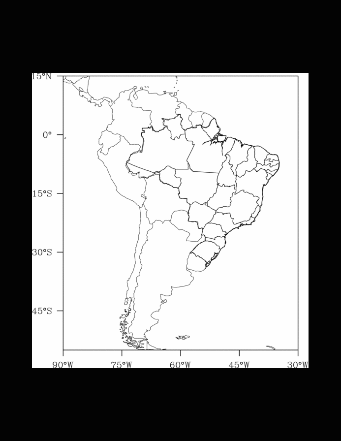
For the NCL users that want to add Brazil political divisions in your
plots, I adapted
http://www.ncl.ucar.edu/Applications/Scripts/polyg_9.ncl script to read
my boundary files and I send you the script, the boundary files and a
GIF file showing the result from this script.
I'm not a NCL expert but I think that it can help those that make plots
to this region.
Mateus da Silva Teixeira
CPTEC/INPE - Brasil
load "$NCARG_ROOT/lib/ncarg/nclscripts/csm/gsn_code.ncl"
load "$NCARG_ROOT/lib/ncarg/nclscripts/csm/gsn_csm.ncl"
;--------------------------------------------------------------
; NCL script that shows how to put political divisions of Brazil
; The divisions are added with 'gsn_add_polyline' function.
; This is script is an adaptation of the script
;
; http://www.ncl.ucar.edu/Applications/Scripts/polyg_9.ncl
;
; The greatest modification is the format of the boundary files. I simply
; put only the lat/lon coordinates in the files,
;
; lat1 lon1 lat2 lon2 lat3 lon3 ...
;
; For more than one fields (or panels) you must add more variables to
; add the polylines. Below, if you plot two panels, you must create a
; second graphic variable, equal to poli variable, for instance:
;
; poli = new(narqs,"graphic")
; poli2 = poli
;
;----------------------------------------------------------
begin
wks = gsn_open_wks("ps","brmap") ; open a ps file
; attributes of the graphics
res = True
res_at_mpDataBaseVersion = "Ncarg4_1"
res_at_mpFillOn = False
res_at_mpOutlineBoundarySets = "National"
res_at_pmTickMarkDisplayMode = "Always"
res_at_mpMaxLatF = 15 ;
res_at_mpMinLatF = -55 ; South America limits
res_at_mpMaxLonF = 330 ;
res_at_mpMinLonF = 270 ;
res_at_gsnFrame = False
res_at_gsnDraw = False
plot = gsn_csm_map(wks,res) ; creates a blank map
; attributes of the polylines
resp = True
resp_at_gsLineColor = "Foreground" ; polylines color
resp_at_gsLineThicknessF = 1.5 ; polylines thickness
arquivos = systemfunc("ls estados_brasil/*.boundary") ; boundary files list
narqs = dimsizes(arquivos) ; total number of files
poli = new(narqs,"graphic") ; variable with polylines
do i=0,narqs-1 ; loop to read boundary files
front = asciiread( arquivos(i), -1, "float" )
nptos = dimsizes(front(0::2)) ; number of the lat/lon points
latlon = new((/2,nptos/),"float") ; array with lat/lon info
latlon(0,:) = (/front(1::2)/) ; latitudes
latlon(1,:) = (/front(0::2)/) ; longitudes
poli(i) = gsn_add_polyline(wks,plot,latlon(1,:),latlon(0,:),resp) ; adding polyline
delete(front) ;
delete(nptos) ; ==> deleting variables to
delete(latlon) ;
end do
gsn_panel(wks,plot,(/1,1/),False) ; plotting ...
; using ImageMagic to convert PS -> GIF
system("convert -trim -density 300 -geometry 800x600 brmap.ps brmap.gif; rm brmap.ps")
end
_______________________________________________
ncl-talk mailing list
ncl-talk_at_ucar.edu
http://mailman.ucar.edu/mailman/listinfo/ncl-talk
_______________________________________________________
Novidade no Yahoo! Mail: receba alertas de novas mensagens no seu celular. Registre seu aparelho agora!
http://br.mobile.yahoo.com/mailalertas/
- application/x-gzip attachment: brazil.states.tar.gz