Date: Wed Sep 25 2013 - 04:52:48 MDT
Dear NCL experts
Hello.
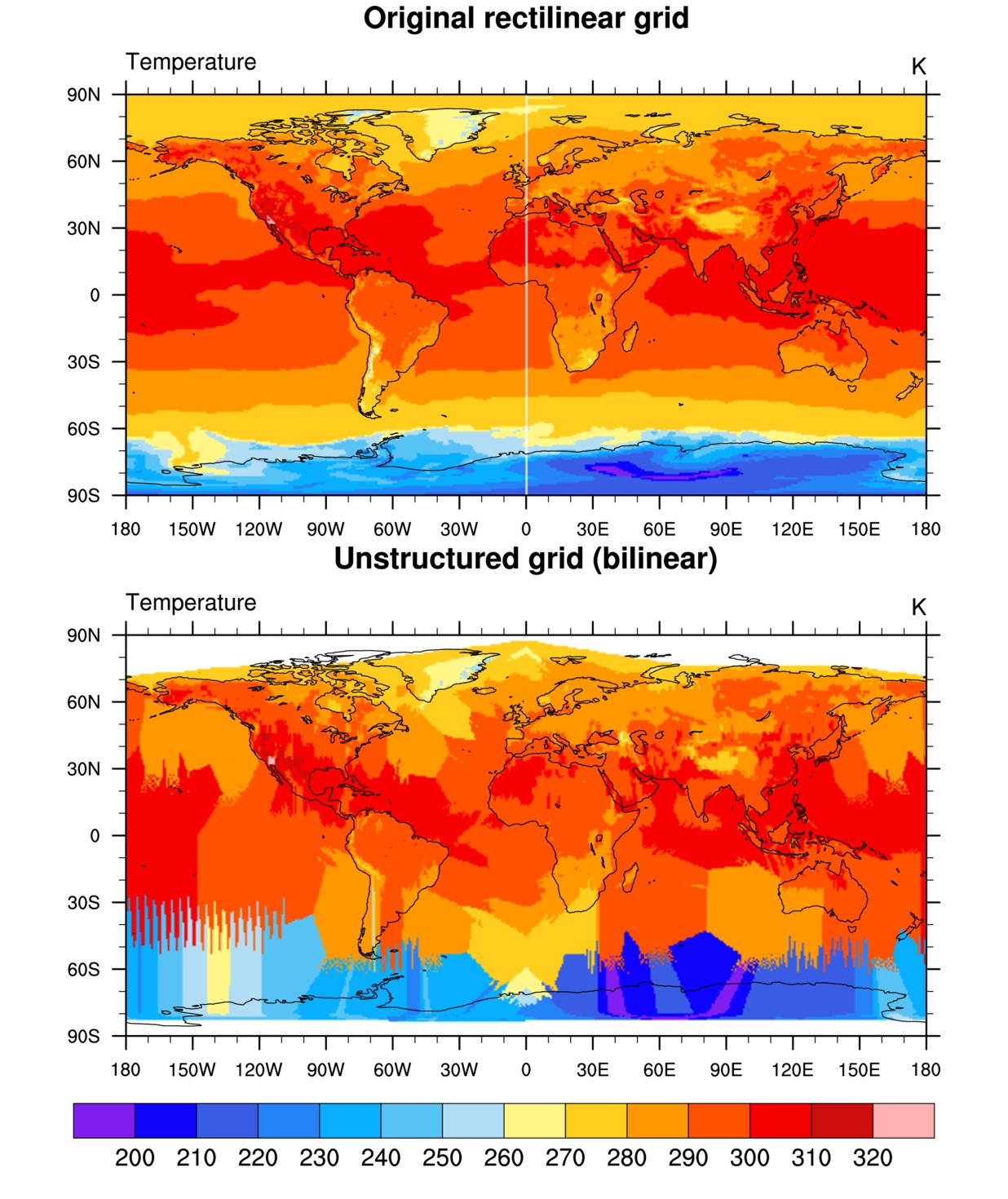
I tried to regrid from a rectilinear grid to an unstructured grid.
But, there is some problem.
I attached the result which has some problem.
In lower panel, there is missing value over land area of polar region.
For my experiments, I need the data which doesn't include the missing value
over land area.
I attached ncl code as follows.
Could you let me know about corrigendum in my code?
Thanks in advance.
===========================================
load "$NCARG_ROOT/lib/ncarg/nclscripts/csm/gsn_code.ncl"
load "$NCARG_ROOT/lib/ncarg/nclscripts/csm/gsn_csm.ncl"
load "$NCARG_ROOT/lib/ncarg/nclscripts/csm/contributed.ncl"
load "$NCARG_ROOT/lib/ncarg/nclscripts/esmf/ESMF_regridding.ncl"
begin
;--Data file containing source grid
src_file = "gfs.t00z.pgrb2f00.nc" ;;---Change (likely)
sfile = addfile(src_file,"r")
;---Get variable to regrid
varname = "TMP_P0_L1_GLL0" ;;---Change (likely)
var = sfile->$varname$ ; Assumption is that "var"
; var =var-273.15
; contains coordinate arrays.
printVarSummary(var) ; Make sure it has coord arrays.
;---Data file containing destination grid
dst_file = "clmi.BCN.2000-01-01_0.47x0.63_gx1v6_simyr2000_c121001.nc<http://clmi.bcn.2000-01-01_0.47x0.63_gx1v6_simyr2000_c121001.nc/>"
;;---Change (likely)
dfile = addfile(dst_file,"r")
dst_lat = dfile->cols1d_lat ;;---Change (likely)
dst_lon = dfile->cols1d_lon ;;---Change (likely)
;---Set up regridding options
Opt = True
;---"bilinear" is the default. "patch" and "conserve" are other options.
Opt@InterpMethod = "bilinear" ;;---Change (maybe)
Opt@WgtFileName = "rect_to_unstruct.nc"
;
; These next two lines only needed if "var" doesn't
; contain coordinate arrays.
;
Opt@SrcRegional = True ;;--Change (maybe)
Opt@SrcInputFileName = src_file ; optional, but good idea
Opt@SrcMask2D = where(.not.ismissing(var),1,0) ; Necessary if
has missing values.
Opt@Pole ="teeth"
Opt@DstGridType = "unstructured"
Opt@DstGridLat = dst_lat ; destination grid
Opt@DstGridLon = dst_lon
Opt@DstRegional = True ;;--Change (maybe)
Opt@DstMask2D = where(.not.ismissing(dst_lat).and.\
.not.ismissing(dst_lon),1,0) ; Necessary if
lat/lon
Opt@DstLLCorner = (/-90.00d, 0.00d /) ;;--Change (maybe)
Opt@DstURCorner = (/ 90.00d, 360.00d /) ;;--Change (maybe)
; has missing values.
Opt@ForceOverwrite = True
Opt@PrintTimings = True
Opt@Debug = True
var_regrid = ESMF_regrid(var,Opt) ; Do the regridding
printVarSummary(var_regrid) ; Check that everything
printMinMax(var_regrid,0) ; looks okay.
;----------------------------------------------------------------------
; Plotting section
;
; This section creates filled contour plots of both the original
; data and the regridded data, and panels them.
;----------------------------------------------------------------------
wks = gsn_open_wks("ps","rect_to_unstruct")
res = True
res@gsnMaximize = True
res@gsnDraw = False
res@gsnFrame = False
res@cnFillOn = True
res@cnLinesOn = False
res@cnLineLabelsOn = False
res@cnFillMode = "RasterFill"
res@lbLabelBarOn = False ; Turn on later in panel
; res@mpMinLatF = min(src_lat)
; res@mpMaxLatF = max(src_lat)
; res@mpMinLonF = min(src_lon)
; res@mpMaxLonF = max(src_lon)
;;--Change (maybe)
mnmxint = nice_mnmxintvl( min(var), max(var), 18, False)
res@cnLevelSelectionMode = "ManualLevels"
res@cnMinLevelValF = mnmxint(0)
res@cnMaxLevelValF = mnmxint(1)
res@cnLevelSpacingF = mnmxint(2)
;---Resources for plotting original data
res@gsnAddCyclic = False ;;---Change (maybe)
res@tiMainString = "Original rectilinear grid"
;
plot_orig = gsn_csm_contour_map(wks,var,res)
;---Resources for plotting regridded data
; res@mpFillOn = True
; res@mpOceanFillColor = "white"
; res@mpLandFillColor = "transparent"
; res@mpFillDrawOrder = "postdraw"
res@gsnAddCyclic = False ;;---Change (maybe)
res@tiMainString = "Unstructured grid (" + Opt@InterpMethod + ")"
res@sfXArray = dst_lon
res@sfYArray = dst_lat
res@trGridType = "TriangularMesh"
plot_regrid = gsn_csm_contour_map(wks,var_regrid,res)
;---Compare the plots in a panel
pres = True
pres@gsnMaximize = True
pres@gsnPanelLabelBar = True
gsn_panel(wks,(/plot_orig,plot_regrid/),(/2,1/),pres)
end
--
--
In-Won Kim
Intergrated Climate System Modeling Lab.
Department of Environmental Atmospheric Sciences
599-1 Daeyeon-dong, Nam-gu
Pukyong National University,
Busan, S.Korea
Tel. +82-51-629-6643
Fax +82-51-629-7991
_______________________________________________
ncl-talk mailing list
List instructions, subscriber options, unsubscribe:
http://mailman.ucar.edu/mailman/listinfo/ncl-talk