NCL Home>
Application examples>
Non-uniform grids ||
Data files for some examples
Example pages containing:
tips |
resources |
functions/procedures
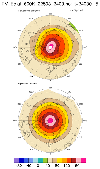
NCL: Equivalent Latitudes
Equivalent latitude
is often used when analyzing potential vorticity (PV) and polar vortex behavior.
The edge of the vortex is defined as the maximum first derivative of PV with respect to equivalent latitude.
You can use NCL's triangular mesh capability to directly contour
equivalent latitudes which are function of time and longitude.
Bodecker Scientific provides a
tutorial
of how to compute equivalent latitude from potential vorticity.
For more information on non-uniform grids that NCL can handle, see the
document "Non-uniform grids that
NCL can contour."
 equiv_lat_1.ncl
:
The file looks like
        double time(time) ;
                time:units = "days as %Y%m%d.%f" ;
        double lat(lat) ;
                lat:long_name = "latitude" ;
                lat:units = "degrees_north" ;
                lat:standard_name = "latitude" ;
        double lon(lon) ;
                lon:long_name = "longitude" ;
                lon:units = "degrees_east" ;
                lon:standard_name = "longitude" ;

        float vortpot_0600K(time, lat, lon) ;
                vortpot_0600K:long_name = "potential vorticity on 0600K surfaceP" ;
                vortpot_0600K:units = "K m2 kg-1 s-1" ;

        float eqlat_0600K(time, lat, lon) ;
                eqlat_0600K:long_name = "equivalent latitude on 0600K surfaceP" ;
                eqlat_0600K:units = "degrees_north" ;
The
eqlat_0600K variable is a function of (time, lat, lon).
The lat/lon information must be provided by setting the resources
sfXArray and
sfYArray. Further, the data array
must be one-dimensional (use
ndtooned).
