NCL Home> Application examples> Data sets || Data files for some examples

Example pages containing: tips | resources | functions/procedures

NCL Graphics: PRISM: Parameter elevation Regression on Independent Slopes Model

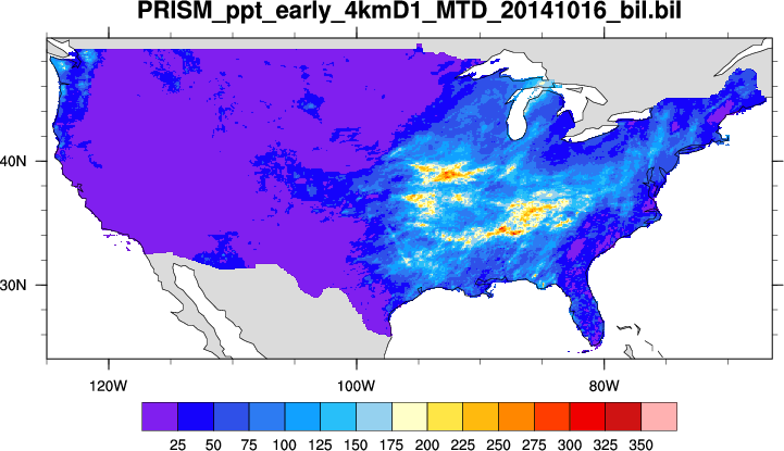
PRISM is a set of monthly, yearly, and single-event gridded data products of mean temperature and precipitation, max/min temperatures, and dewpoints, primarily for the United States. In-situ point measurements are ingested into the PRISM (Parameter elevation Regression on Independent Slopes Model) statistical mapping system. The PRISM products use a weighted regression scheme to account for complex climate regimes associated with orography, rain shadows, temperature inversions, slope aspect, coastal proximity, and other factors. Climatologies (normals) are available at 30-arcsec (800 meters) and monthly data are available at 2.5 arcmin (4 km) resolution. PRISM is the USDA's official climatological data.

NCAR's Climate Data Guide (CDG) provides more information.

A .BIL extension means 'Band-Interleaved-Format". This is a 'flat' binary file containing numeric values. The size (number of values) is NBANDS x NROWS x NCOLS. NCL's fbindirread and cbinread can be used to read these files.
NOAA's Physical Sciences Division makes the PRISM datasets available in NetCDF format. See: http://www.esrl.noaa.gov/psd/data/gridded/data.prism.html

Please acknowledge and use of the data with an acknowledgement such as "Prism data provided by the NOAA/OAR/ESRL PSD, Boulder, Colorado, USA, from their Web site at http://www.esrl.noaa.gov/psd/".

prism_1.ncl: A simple read (here, fbindirread) and plot of a binary file. Details about the file are included in the script documentation.