landsea_mask
Returns a grid that contains a land/sea mask given any latitude and longitude array.
Prototype
load "$NCARG_ROOT/lib/ncarg/nclscripts/csm/gsn_code.ncl"      ; These four libraries are automatically
load "$NCARG_ROOT/lib/ncarg/nclscripts/csm/gsn_csm.ncl"       ; loaded from NCL V6.4.0 onward.
load "$NCARG_ROOT/lib/ncarg/nclscripts/csm/contributed.ncl"   ; No need for user to explicitly load.
load "$NCARG_ROOT/lib/ncarg/nclscripts/csm/shea_util.ncl"

	function landsea_mask (
		basemap [*][*] : byte,
		lat            : numeric,
		lon            : numeric
	)

	return_val [*][*] :  integer
Arguments
basemapA two-dimensional array of type byte that contains a 1 x 1 degree grid of baseline land/sea mask. The user can modify this file if they so choose prior to its use. Note: A variable of type byte may readily be compared to values of type integer (see below).
latA one- or two-dimensional array of latitudes.
lonA one- or two-dimensional array of longitudes. Acceptable values range from -180 to 359.99.
Return value
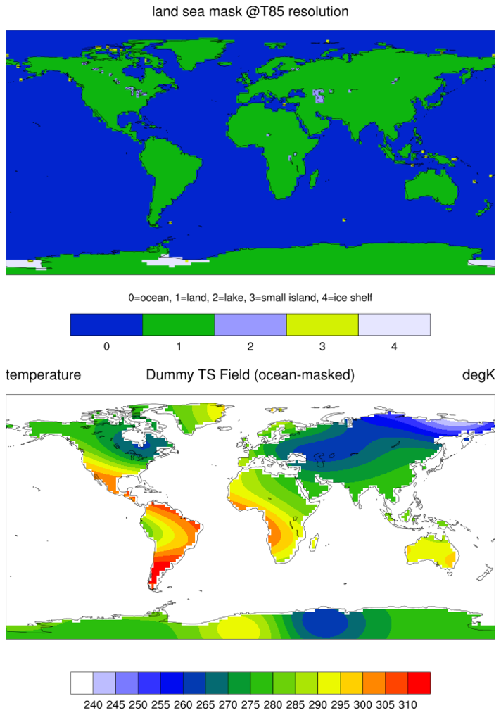
A two-dimensional array of type byte is returned. It contains five possible values: 0=ocean, 1=land, 2=lake, 3=small island, 4=ice shelf. The size will be the size of lat and lon. If the user inputs a scalar value for lat and lon, then the return value will be a single value.
Description
This function returns a grid that contains a land/sea mask given any (e.g. gaussian, fixed offset, curvilinear) latitude and longitude array. The return value can then be applied to any array on the same grid using mask.
The 1x1 degree basemap is distributed with NCL and may be accessed via the path:
$NCARG_ROOT/lib/ncarg/data/cdf/landsea.nc
See Also
Examples
In the examples below, it is assumed that array@_FillValue is set for use in mask.
Example 1
Example 2
Values at land and small island points will be set to _FillValue in the array data after creating a new land/sea mask from one-dimensional lat/lon variables:
   a    = addfile("$NCARG_ROOT/lib/ncarg/data/cdf/landsea.nc","r")
   lsdata = a->LSMASK
   lsm  = landsea_mask(lsdata,data&lat,data&lon)
   data = mask(data,lsm.eq.1,False)
   data = mask(data,lsm.eq.3,False)
Example 3
All values, expect for ocean points, will be set to _FillValue in the array data after creating a new land/sea mask from one-dimensional lat/lon variables:
; assume data is 3D (time,lat,lon)
  a    = addfile("$NCARG_ROOT/lib/ncarg/data/cdf/landsea.nc","r")
  lsdata = a->LSMASK
  lsm = landsea_mask(lsdata,data&lat,data&lon)

; lsm is a 2D array, in order to use it in mask, we must conform it
; to the size of the 3D array "data".
  data = mask(data,conform(data,lsm,(/1,2/)).ge.1,False)
Example 4
All values, expect for ocean points, will be set to _FillValue in the array data after creating a new land/sea mask from two-dimensional lat/lon variables:
; data is 2D w/ 2D lat/lon coordinate variables (TLAT,TLON).
  a = addfile("$NCARG_ROOT/lib/ncarg/data/cdf/landsea.nc","r")
  lsdata = a->LSMASK
  lsm = landsea_mask(lsdata,TLAT,TLON)

; lsm is a 2D array that can be used directly in mask
  data = mask(data,lsm.ge.1,False)
Example 5
A sample script which will:
- generate a user specified global mask
- generate a netCDF file
- plot the generated mask.
Keep in mind that the NCL provided mask is 1x1 so higher resolution make not be well accomodated.
;==========================================================
; User Specifications
;==========================================================
nlat = 128
mlon = 256
typeMask = "integer"     ; "byte" [default] or "integer"

grdType = 0              ; 0=gaussian , 1=regular , 2=regular offset
lonStrt = 0              ; 0 [GM] or -180 [Dateline]

diro = "./"
filo = "SampleLandSeaMask.nc"

PLOT = True              ; create a plot [ps]
;==========================================================
; End Required User Specifications
; Note: User may edit the mask below
;==========================================================

load "$NCARG_ROOT/lib/ncarg/nclscripts/csm/gsn_code.ncl"
load "$NCARG_ROOT/lib/ncarg/nclscripts/csm/gsn_csm.ncl"
load "$NCARG_ROOT/lib/ncarg/nclscripts/csm/contributed.ncl"
load "$NCARG_ROOT/lib/ncarg/nclscripts/csm/shea_util.ncl"

function localByte2Int ( x:byte )
local dimx, X
begin
  delete(x@_FillValue)

  dimx = dimsizes(x)
  X    = new ( dimx, "integer", "No_FillValue")
  X    = x
  return(X)
end

begin

  if (grdType.eq.0) then      ; Gaussian [ S->N, GM eastward]
      lat  = latGau(nlat, "lat", "latitude", "degrees_north")
      lon  = lonGlobeF(mlon, "lon", "longitude", "degrees_east")
      gw   = latGauWgt(nlat, "lat", "gaussian weights", "")
  end if

  if (grdType.eq.1) then      ; Regular  [ 90S->90N, GM eastward]
      lat  = latGlobeF(nlat, "lat", "latitude", "degrees_north")
      lon  = lonGlobeF(mlon, "lon", "longitude", "degrees_east")
  end if

  if (grdType.eq.2) then      ; Regular offset from pole and GM
      lat  = latGlobeFo(nlat, "lat", "latitude", "degrees_north")
      lon  = lonGlobeFo(mlon, "lon", "longitude", "degrees_east")
  end if

  if (lonStrt.lt.0) then
      lon = (/ lon - 180. /)  ; subtract 180 from all values
      lon&lon = lon           ; update coordinates
  end if

                              ; read in land/sea mask basemap file
  b    = addfile("$NCARG_ROOT/lib/ncarg/data/cdf/landsea.nc","r")

; lsm: five possible values: 0=ocean, 1=land, 2=lake, 3=small island, 4=ice shelf

  if (isvar("typeMask") .and. typeMask.eq."integer") then
      lsm  = localByte2Int( landsea_mask(b->LSMASK,lat,lon) ) ; type is "integer"
  else
      lsm  = landsea_mask(b->LSMASK,lat,lon)                  ; type is "byte"
  end if
  lsm@long_name = "Land-Sea Mask"
  lsm@units     = "0=ocean, 1=land, 2=lake, 3=small island, 4=ice shelf"
  printVarSummary(lsm)

;=================== OPTIONAL =============================
; Manually edit lsm [type byte] to create a custom land mask. [range 0-7 if byte]
;==========================================================
 ;lsm  = where (lsm.eq.2, 0, lsm) ; make lakes "ocean"
 ;lsm  = where (lsm.eq.2, 1, lsm) ; make lakes "land"
 ;lsm  = where (lsm.eq.3, 1, lsm) ; make island "land"
 ;lsm  = where (lsm.eq.4, 1, lsm) ; make ice "land"
 ;lsm@units     = "change as required"

;==========================================================
; Create netCDF
;==========================================================
   system("/bin/rm -f "+diro+filo)
   ncdf = addfile (diro+filo , "c")

   ncdf@title = "Land-Sea Mask"
   ncdf@creation_date = systemfunc("date")
   ncdf->LSMASK = lsm

;==========================================================
; Create netCDF
;==========================================================
if (PLOT) then

   wks = gsn_open_wks("ps","lsmask")
   gsn_define_colormap(wks,"wh-bl-gr-ye-re")

   res = True
   res@mpFillOn         = False                ; do not color-fill the map
   res@gsnTickMarksOn   = False                ; turn off all tick marks
   res@mpPerimOn        = True                 ; turn the map perimeter on
   res@mpPerimDrawOrder = "PostDraw"           ; draw the map perimeter last
   res@cnLinesOn        = False                ; turn off the contour lines
   res@cnLineLabelsOn   = False                ; turn off the contour line labels
   res@cnLevelSelectionMode = "ExplicitLevels" ; explicitly set the levels via cnLevels
   res@cnLevels         = (/1.,2.,3.,4./)      ; set the levels
   res@cnFillOn         = True                 ; turn on color fill
   res@cnFillMode       = "RasterFill"         ; use raster fill
   res@cnFillColors     = (/60,100,20,140,5/)  ; set the colors that will be used to color fill
   res@lbLabelStrings   = ispan(0,4,1)         ; labels for the labelbar boxes
   res@lbLabelAlignment = "BoxCenters"         ; put the labels in the center of the label bar boxes
   res@lbTitleString    = "0=ocean, 1=land, 2=lake, 3=small island, 4=ice shelf"  ; labelbar title
   res@lbTitleFontHeightF = 0.0125             ; labelbar title font height

   plot = gsn_csm_contour_map_ce(wks,lsm,res)
end if
end