CALIPSO data are available as Level-2 and as part of the CFMIP-OBS (Cloud Feedback Model Intercomparison Program) a protocol to evaluate clouds in climate and weather prediction models based on satellite observations has been designed.
Example pages containing:
tips |
resources |
functions/procedures
CALIPSO data are available as Level-2 and as part of the CFMIP-OBS (Cloud Feedback Model Intercomparison Program) a protocol to evaluate clouds in climate and weather prediction models based on satellite observations has been designed.
This site has a Calipso example. However, the site is updated so additional Calipso examples may be added.
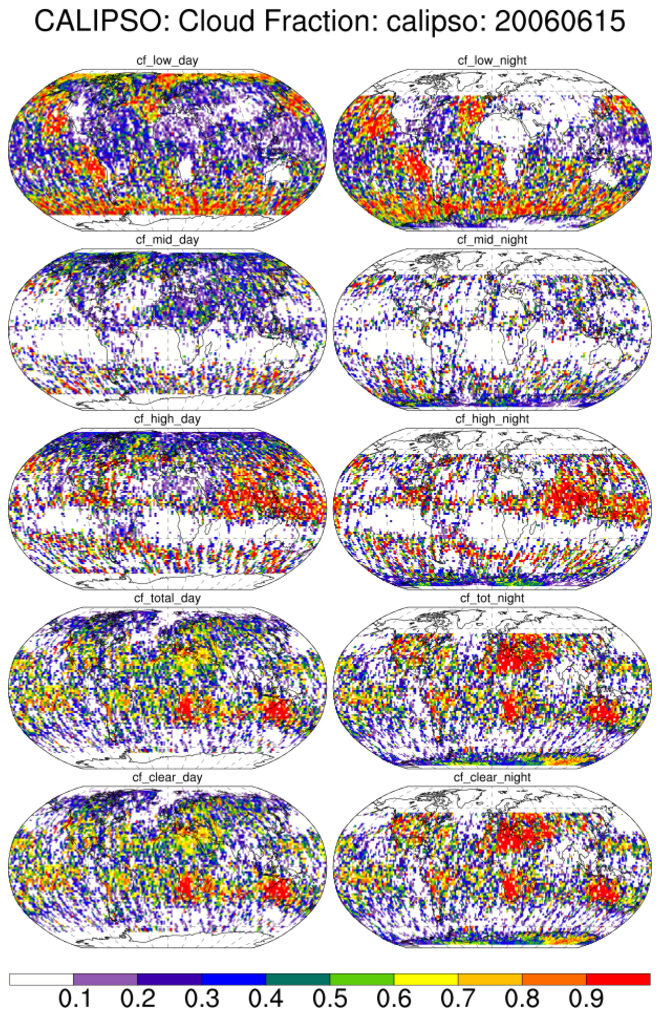
calipso_1.ncl:
CALIPSO cloud fractions (low, middle, high, total and clear) for June 6, 2006.
The file used in this example was obtained from: ftp://ftp.climserv.ipsl.polytechnique.fr/cfmip/GOCCP/3D_CloudFraction/grid_2x2xL40/

 calipso_2.ncl:
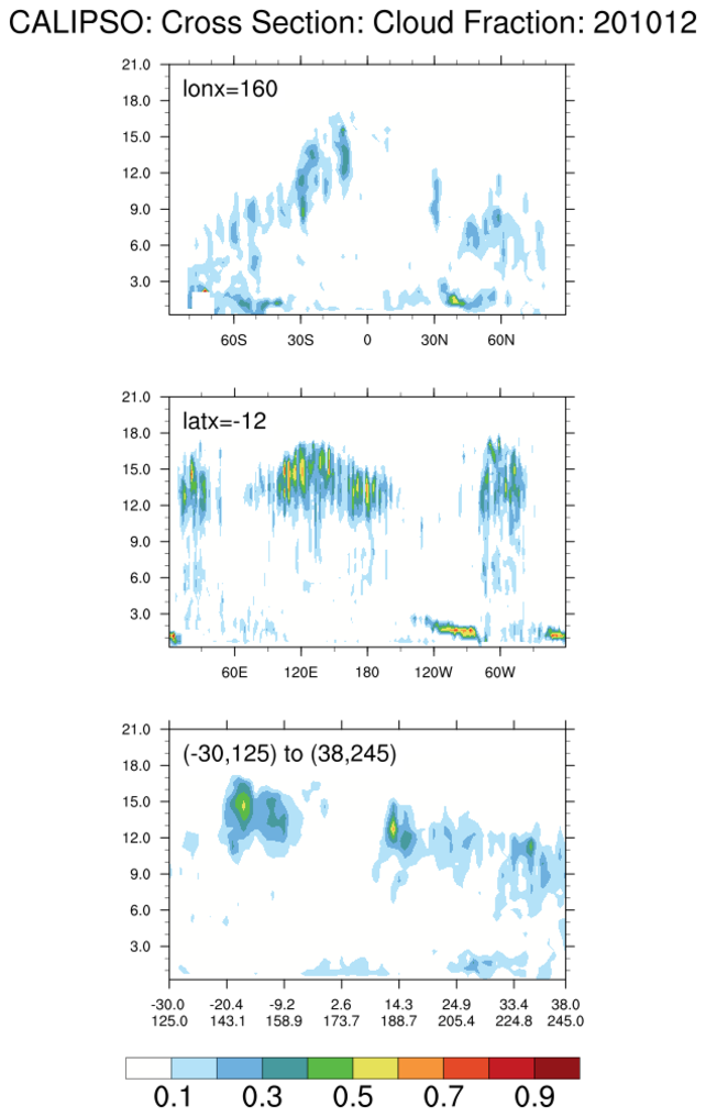
Monthly mean vertical profiles and cross-sections for CALIPSO cloud fractions for Dec 2010.
calipso_2.ncl:
Monthly mean vertical profiles and cross-sections for CALIPSO cloud fractions for Dec 2010.
The file used in this example was obtained from: ftp://ftp.climserv.ipsl.polytechnique.fr/cfmip/goccp/3D_CloudFraction/CMOR/grid_2x2xL40/3D_2_2_40_avg_clc/obs4cmip5/observations/atmos/clcalipso/mon/grid/IPSL/CALIPSO/CALIOP/v20110323/
 calipso_3.ncl:
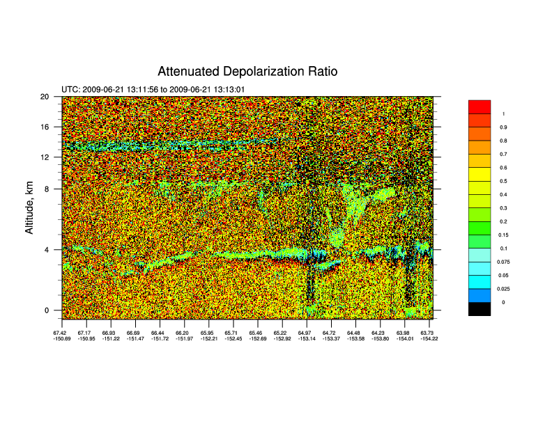
This figure shows high clouds, starting around 65.46 N Latitude, and
a small smoke plume from 66.20 to 65.71 N latitude in the lower altitudes.
The lidar_altitudes.txt file
is used for altitude informatiion. The altitudes are based from a paper
here: http://www-calipso.larc.nasa.gov/products/
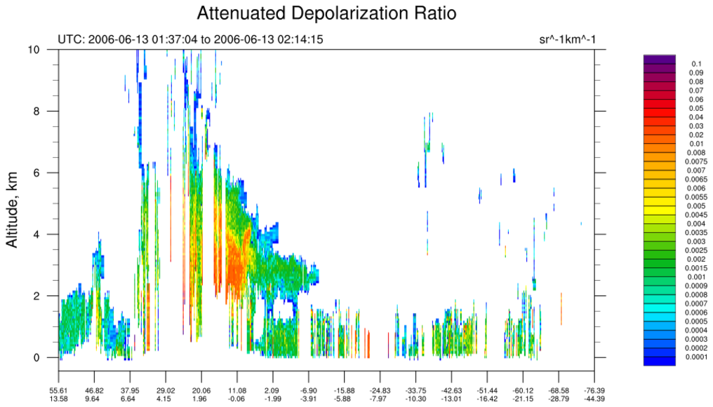
calipso_3.ncl:
This figure shows high clouds, starting around 65.46 N Latitude, and
a small smoke plume from 66.20 to 65.71 N latitude in the lower altitudes.
The lidar_altitudes.txt file
is used for altitude informatiion. The altitudes are based from a paper
here: http://www-calipso.larc.nasa.gov/products/
The CALIPSO subsetter tool was used to find CALIPSO files. Any CALIPSO file should do. The subsetter tool saves the trouble of isolating specific latitude and longitude regions.
This script was donated by James "Mike" Madden (U. Alaska, Fairbanks) who edited the original script developed by Cory Wolff (NCAR).
Note: As of v6.1.2, NCL does not read HDF 'vdata'. The lidar altitudes may be obtained via:
hdp dumpvd CAL_LID_L2_05kmAPro-Prov-V3-01.2009-07-10T14-32-05ZD.hdf_Subset.hdf > vdata
 Then edit this Vdata file to get something like:

 Product_ID = "L2_LIDAR"
 Date_Time_at_Granule_Start = "2009-07-10T14:50:43.766000Z"
 Date_Time_at_Granule_End = "2009-07-10T14:59:00.668400Z"
 Initial_Subsatellite_Latitude = 0.039497
 Initial_Subsatellite_Longitude = -15.592452
 Final_Subsatellite_Latitude = 30.027323
 Final_Subsatellite_Longitude = -22.398491
 Lidar_Data_Altitudes = (/29.796324, 29.616693, 29.437065, 29.257437, 29.077806, \
                          28.898178, 28.718550, 28.538919, 28.359291, 28.179663, \
                          28.000032, 27.820404, 27.640776, 27.461147, 27.281517, \
                          27.101889, 26.922260, 26.742630, 26.563002, 26.383373, \
                          26.203743, 26.024115, 25.844486, 25.664856, 25.485228, \
                          25.305599, 25.125969, 24.946341, 24.766712, 24.587084, \
                          24.407454, 24.227825, 24.048197, 23.868567, 23.688938, \
                          23.509310, 23.329679, 23.150051, 22.970423, 22.790792, \
                          22.611164, 22.431536, 22.251907, 22.072277, 21.892649, \
                          21.713020, 21.533390, 21.353762, 21.174133, 20.994503, \
                          20.814875, 20.635246, 20.455616, 20.275988, 20.156235, \
                          20.096359, 20.036482, 19.976606, 19.916729, 19.856853, \
                          19.796978, 19.737101, 19.677225, 19.617348, 19.557472, \
[SNIP]
                          4.827897, 4.768021, 4.708144, 4.648268, 4.588391, \
                          4.528515, 4.468639, 4.408763, 4.348886, 4.289010, \
                          4.229134, 4.169257, 4.109381, 4.049504, 3.989628, \
                          3.929752, 3.869876, 3.809999, 3.750123, 3.690247, \
                          3.630370, 3.570494, 3.510618, 3.450742, 3.390865, \
                          3.330989, 3.271112, 3.211236, 3.151360, 3.091484, \
                          3.031607, 2.971731, 2.911855, 2.851978, 2.792102, \
                          2.732226, 2.672349, 2.612473, 2.552597, 2.492720, \
                          2.432844, 2.372968, 2.313091, 2.253215, 2.193339, \
                          2.133462, 2.073586, 2.013710, 1.953833, 1.893957, \
                          1.834081, 1.774204, 1.714328, 1.654452, 1.594576, \
                          1.534699, 1.474823, 1.414947, 1.355070, 1.295194, \
                          1.235318, 1.175441, 1.115565, 1.055689, 0.995812, \
                          0.935936, 0.876060, 0.816183, 0.756307, 0.696431, \
                          0.636554, 0.576678, 0.516802, 0.456925, 0.397049, \
                          0.337173, 0.277296, 0.217420, 0.157544, 0.097667, \
                          0.037791, -0.022085, -0.081961, -0.141838, -0.201714, \
                         -0.261590, -0.321467, -0.381343, -0.441219/)

And you have to work on these for every hdd file.
 calipso_4.ncl:
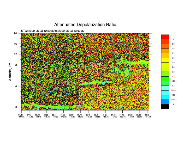
Vertical cross-section for CALIPSO "Total_Backscatter_Coefficient_532". Minor variations from calipso_3.ncl
calipso_4.ncl:
Vertical cross-section for CALIPSO "Total_Backscatter_Coefficient_532". Minor variations from calipso_3.ncl