NCL Home>
Application examples>
Models ||
Data files for some examples
Example pages containing: tips | resources | functions/procedures
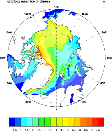
NCL: PIPS
PIPS: U.S. Navy Polar Ice Prediction

pips_1.ncl: Creates single pane images of scalar variables on a polar projection.
gsn_csm_vector_scalar_map_polar is the plot interface that puts plots vectors on top a scalar field.
The datafile used in this example has a boundary problem, so that the first column of longitude data is bogus. In order to plot this, this column had to be removed.
This is a very large grid and it takes a while to draw. If you want to subset the data, you need to do it in both the attribute definition and the plot call. e.g.
   hi@lon2d = lon2d(:,1::10)
   hi@lat2d = lat2d(:,1::10)
   plot     = gsn_csm_contour_map_polar(wks,hi(::10,::10),res)